Tavşanlı Zone field trip, part 3

Picking up where we left off last time, we were in some partly-serpentenized peridotite, part of the Burham Ophiolite in Turkey’s Tavşanlı Zone, an ancient tectonic suture.

Our next stop on the field trip allowed us to visit some diabase dikes:

tav_3_01

Here’s a close-up of the right contact of the dike with the host peridotite:

tav_3_02

The field notebook’s long edge is ~18 cm. And here it is again, annotated:

tav_3_02anno

Near the village of Oranheli, we stopped to examine a jadeite meta-granitoid, a rock only a metamorphic petrologist could love. There were, however, a lot of metamorphic petrologists on the trip, and they were very keen on checking it out. This was the first of many occasions when random Turkish citizens would stroll up to our odd group to find out just what the hell we were doing:

tav_3_03

Further along, we saw a meta-basite (meta-basalt) within the meta-granitoid, and there I got a refreshing whiff of structure. Here’s a random isoclinal fold of a meta-granitoid dike cross-cutting the meta-basite, with a Turkish 1-lira coin (about the same size as a U.S. quarter) for scale:

tav_3_04

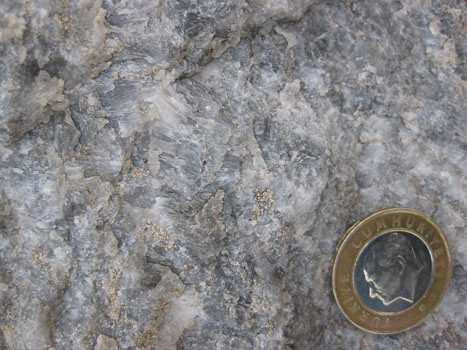
Next up were some very cool rocks: marbles with extremely elongated calcite crystals.

tav_3_05

These needle-like crystals are interpreted as being pseudomorphs of aragonite, the form of CaCO3 which is stable at high pressures and low temperatures.

tav_3_16

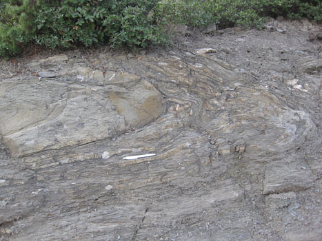
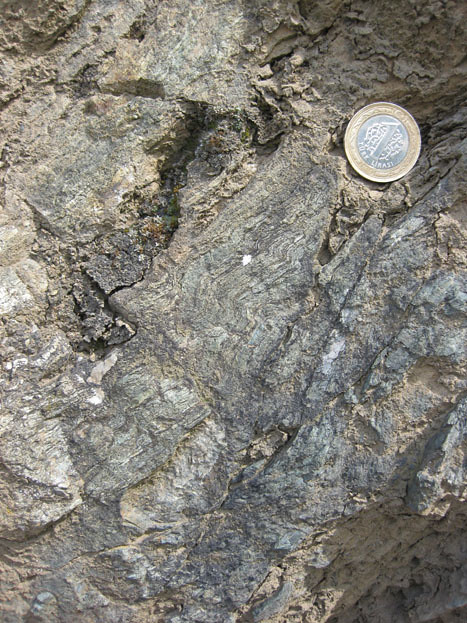
A bit further on, we return to metamorphosed shale and graywacke (now schist and “grayfels”), sheared out and pervasively deformed at blueschist conditions. I took a few photos of charismatic folds in the unit:

tav_3_09

Annotated, roughly showing the trace of foliation:

tav_3_09anno

Sandy layer folded over into a recumbent position, set in a sheared mass of meta-shale:

tav_3_06

Thicker sandy layer, in a recumbent isoclinal fold (white pen, 14 cm long, for scale):

tav_3_08

Zooming in on the above photo, to show the lovely, smaller wavelength parasitic folds which decorate the snout of the big fold:

tav_3_07

Extensional fractures along an isoclinally-folded, recumbent sandy layer:

tav_3_10

Small S-folds in the sheared shale (just above hammer):

tav_3_11

Coming down onto this roadside outcrop of sheared shale and graywacke were cobbles and boulders of float from somewhere up above. They were of a quartz-pebble conglomerate that showed a stretching lineation. Check out these two faces of typical samples:

tav_3_14

tav_3_15

Now, here they are again, with the X, Y, and Z axes of the strain ellipsoid (longest, intermediate, and shortest, respectively) labeled for your benefit.

tav_3_14anno

tav_3_15anno

This conglomerate has been sheared into a lovely L-S tectonite, with X>Y~Z. In other words, it’s mostly lineated, with only a weakly-defined foliation, indicating the stress field was mostly constrictional. (I collected a muddy sample of this stretched-pebble meta-conglomerate, and when I washed it off in the hotel shower the next morning, I was delighted what a cool sample I had selected. It has some awesome structural features; I’ll show it to you some other time…)

Our final stop of Day 1 of the trip was this spectacular overview of the Kocasu Gorge, a canyon which cuts across the structural trend of the area at approximately a right angle. (The canyon cuts north-south; the strike of the folded & thrusted rock units runs approximately east-west.)

tav_3_13

As the sun set, Aral showed us where we were, and the overall synclinal structure of the area.

tav_3_12

I recorded it in my field notebook like this:

kocasu

With this context established, we loaded back on the bus and drove for a couple of hours to get to a town with a decent hotel. We dined and slept, and the next morning got up ready for more suture-zone rocks.

Tavşanlı Zone field trip, part 2

Yesterday, I shared a few thoughts about the first couple of stops on the field trip I took earlier this month from Istanbul to Ankara, prior to the Tectonic Crossroads conference. Today, we’ll pick up with some images and descriptions from the next few stops.

After lunch, our next stop brought us to a relatively low-metamorphic-grade outcrop of sheared graywacke (dirty sandstone) and shale. As you can imagine, it wasn’t particularly photogenic. Bedding was continuous only over a scale of a meter or two. It’s what suture-zone workers call “broken formation,” part way between undeformed rocks and a full-blown mélange. (It’s internally sheared up, but not yet mixed with adjacent formations.)

Looking back the way we had driven in, though (i.e., looking to the north), we could see the west-ward dipping limb of a large syncline exposed on the mountainside over yonder:

tav_1_08

Annotated version:

tav_1_08anno

The Orhanler Formation is the lowermost unit, layers of graywacke and shale that are probably Triassic in age. It is overlain by the thin sandstones of the Bayırköy Formation (Liassic), and then the limestone which is proving so irresistible to quarry excavators, the upper Jurassic Bilecik Limestone.

Our fourth stop was one of the ones that got me really excited. In fact, almost everyone on the trip seemed to get pumped up from visiting this outcrop. Check it out:

tav_2_01

The yellow field notebook’s long edge measures ~18 cm. Behind the notebook, my friends, is a layered gabbro. The stripes you see result from differing ratios of light and dark colored minerals — plagioclase and pyroxene, mainly. But why is it layered? Is this an example of a cumulate texture; a primary igneous structure resulting from the settling of crystals onto the floor of a magma chamber? Or is this a tectonic foliation, resulting from strain the rock has accumulated? It was introduced to the participants on the field trip as an example of the former, but several of us found this argument less than totally convincing, as the size of this rock body is ~200 km long and ~2 km thick. It’s awfully hard to envision a magma body that size. I found it easier to imagine this as a chunk of the mantle, as Alain Tremblay suggested to the group.

As I poked around the outcrop, I found something which was consistent with a deformational (rather than cumulate) origin to the layering…

tav_2_07

That’s an S-fold! Turn this cobble around, and on the other side, you can see a Z-fold:

tav_2_08

I suppose that tight little folds like this could have come in some stage of ductile deformation after an original cumulate layer formed, but that would require an episode of deformation not required by the foliation hypothesis. If these are planes formed by mantle flow, I’d expect a few small folds in those layers at the time that flow was forming them. Besides the blueschists and eclogites, the Tavşanlı Zone includes an ophiolitic suite, and having chunks of mantle there would in no way be a shocker.

Regardless of the origin of the mineralogical layering, I think we can all be pleased to learn that it is deformed. A series of “reverse” ductile shear zones cut across the layering, as you may be able to discern in this photo:

tav_2_02

Notice how the gabbro’s layers deflect towards the fault(s) in a “drag fold” fashion, tipping over to the left. Close up:

tav_2_03

Left of the notebook, you can see this gentle deflection quite nicely:

tav_2_04

This is sweet, right? I’m loving it.

tav_2_05

A close-up shot that particularly satisfies me:

tav_2_06

Note the thinning and rotation of the mineralogical layers as you get closer to the shear band at the center of the shear zone itself (far right of photo). Pen for scale.

We also stopped at a proper peridotite outcrop (no one’s arguing that this one isn’t mantle), which had serpentine veins cutting though it:

tav_2_09

More later

By the way, this blog’s move to the AGU servers has been postponed until probably Monday.

Tavşanlı Zone field trip, part 1

Before the Tectonic Crossroads conference two weeks ago, I had the good fortune to participate in a Istanbul-to-Ankara geology field examining the Tavşanlı Zone, a tectonic suture zone where a portion of the Tethys Ocean basin closed. This paleo-convergent boundary is marked by a suite of interesting rocks, including blueschists, ophiolites, and eclogites. I’d like to share with you some of the things I saw along the trip.

This is one of the trip leaders, Aral Okay (pronounced “Oh-kai,” okay?), discussing the general geology of the area at our first stop. (The other trip leader was Donna Whitney.)

tav_1_01

I think in general, you can make out the east-west trend of the rock units on Aral’s map (where they aren’t obscured by alluvium). This reflects the approximate north-south convergence of the Tethys closure in Turkey. To visualize this, I’d like to call your attention to a paleogeographic interpretation of the Tethys Ocean from Ron Blakey, the talented mapmaker from Northern Arizona University:

tethys

See all those colliding east-west-oriented crustal fragments in the northwestern Tethys? Those are the pieces that will comprise future Turkey. As you can imagine, rocks caught up in these tectonic collisions got both deformed and metamorphosed. Some of them were even subducted to ~80 km depth, and then brought back up to the surface! At our first stop, we saw some blueschist-grade rocks that had a phyllitic texture. Here’s two of them:

tav_1_02

As usual, my eye was drawn towards the structures visible in these rocks. Here are a couple of nice little folds:

tav_1_03

tav_1_05

(The Turkish 1-lira coin is the same size as a U.S. quarter.)

I found this to be an interesting portion of the outcrop:

tav_1_04

That’s green phyllite on the left, and blue phyllite on the right. Allow me to annotate it for you:

tav_1_04anno

“Blueschist” and “greenschist” refer to two assemblages of minerals which supposedly represent different combinations of temperature and pressure. They are examples of metamorphic “facies,” as illustrated in this image:

facies

Image redrawn and modified by me from Figure 3 of Bousquet, et al. (2008), which is itself modified from Oberhänsli, et al. (2004), and also from University of British Columbia (1997), which is modified from Yardley (1988).

Theoretically, blueschists and greenschists should be forming at different combinations of pressure and temperature. Blueschist forms at high pressures, but relatively low temperatures. But here we have an outcrop of blueschist that is right adjacent to a greenschist (medium temperature and pressure), with no faulting in between. It was suggested to me by a blueschist expert that this was likely a reflection in differences in the initial composition of the protoliths. I found this explanation less than completely satisfying, but there was no time to discuss, for we were being called back to the bus, already gunning its engine and ready to roll down the road.

At our second stop, we found some metamorphic rocks that showed clear textural evidence of having had pyroclastic protoliths:

tav_1_06

There were lots of chunky bits in there.

tav_1_07

So it wasn’t just pelitic (muddy) rocks that were getting metamorphosed in this Tethyan suture zone, but volcanic rocks too!

More later… when we move on to stop #3

Rumeli Hisarı

Right after I got to Istanbul on this most recent trip, I took a taxi from my hotel down to the Bosphorus, to check out the Rumeli Hisarı, a fort complex built in 1452 by Sultan Mehmet the II in anticipation of the following year’s siege of Constantinople. It’s constructed at the narrowest point on the Bosphorus (660 m wide), with the aim of controlling boat traffic coming from the Black Sea. This narrow spot is today where they have the second of two bridges spanning the Bosphorus. It looks like this:

rumelihisari08

It’s in Europe; that’s Asia on the far right of the photo. A few more shots of the fortress’s pattern of towers and interconnecting walls:

rumelihisari04

rumelihisari05

rumelihisari01

Inside, I was pleased to note the variety of building stones. Here’s a nice porphyritic andesite which was a common constituent of the walls:
rumelihisari02

And a folded limestone:

rumelihisari06

Here are some yellowish blocks that are weathering away faster than the mortar which holds them in place. There is a Turkish 1-lira coin in front of the dark block near the center, to provide a sense of scale:

rumelihisari11

Here’s a similar phenomenon playing out with some bricks used to make an archway, except here the mortar is the more rapidly weathering component:

rumelihisari07

Check out this slab of brick… it’s got a curious adornment:

rumelihisari10

Zoomed in to show this detail:

rumelihisari09

Dog prints! Sometime a long time ago, maybe more than 500 years ago, a brick maker put out slabs of clay to dry, and some long-dead dog walked across it. The dog’s footprints are a kind of “historical trace fossil” that was then incorporated into this ancient structure.

Visiting the Rumeli Hisarı was a pleasant experience. I walked down along the Bosphorus next, peering into its surprisingly clear waters and counting jellyfish, then got a pide at a cafe. I caught another cab back to the hotel, and eventually fell asleep, a victim of jet lag…

rumelihisari03

Photos from Virginia Geological Field Conference

For the second year in a row, more exotic travel plans meant that I wasn’t able to attend the superb Virginia Geological Field Conference. I see that they have now posted some photos on the group’s Facebook page, so go check them out to see what we both missed last weekend. Here’s a taste:

Sheared meta-conglomerate:

Metamorphosed mantle (?) xenoliths:

Güvem geoheritage site, Turkey

Looks like I’m late to the party…

While I was away, apparently the geoblogosphere went on a rampage of cooling columns. Everyone was posting images of their favorite columnar joints, and I was left out in the cold. Let me remedy that now. As it turns out, I was visiting some columns while everyone else was writing about them. Here are some images from the Güvem area of Turkey, north of Ankara, where there are a mix of late Miocene lake sediments and intercalated volcanic rocks, including these basalt flows. We stopped to visit them last Wednesday on our way to the North Anatolian Fault:

guvem_columns11

The dark entablature looms above:guvem_columns01

A nice central panel with a good cross-section of the flow: guvem_columns03

Around the corner, some more:
guvem_columns04

I ran across the street (and a stream) to check out a similar exposure there:guvem_columns05

Zooming in:guvem_columns06

Close-up of a few columns (with my hand for scale):guvem_columns08

Looking up along the columns:guvem_columns09

And a few more shots of the scene:guvem_columns10

guvem_columns02

A full list of Turkish geoheritage sites may be found at the end of this document. Lockwood maintained a list of the other blog posts in this meme here, which I’ll quote below since it’s so nicely laid out already:

Geotripper, here, here and here,
Sam at Geology Blues
Phillip, also at Geology Blues
Silver Fox, and another columnar post here.
Glacial Till and another!
Life in Plane Light: Squashed columns!
Aaron at Got The Time
Geology Rocks
Dana at En Tequila Es Verdad
Cujo 359 (see comment on Dana’s post for description)
Wayne at Earthly Musings has a gorgeous photo of columns below the rapids at Lava Falls in Grand Canyon.
MB Griggs at The Rocks Know has photos of what may well be the most perfect columns in the world.
Jessica, AKA Tuff Cookie, showcases a variety in different rock types.
Hypocentre finds columns in a very unlikely place, as well as a spectacular photo of radiating columns.
Dave Tucker at Northwest Geology Field Trips displays precisely one slew of columnar displays in Washington State.
Dave Bressan at History of Geology shares the first printed image of columnar basalts, from 1565.
A couple more variations from Dana’s and my driving about W. Oregon.
Dr. Jerque has some spectacular examples from the bottom of the Grand Canyon.
Silver Fox Has another (better than mine) photo of horizontal columns in a set of dikes, and points out a couple more links to columny goodness (not to be confused with calumny, which is not good)
Dan McShane offers some more Washington State columns.
Garry Hayes, who deserves credit for starting this meme (see first links in the list, above), adds yet another set of photos from the opening of the Atlantic Ocean, and a lovely guest photo by Ivan Ivanyvienen, of columnar jointing in rhyolite at the San Juan Precordillera.
Update, October 4: Eric Klemetti- who did his doctoral work just down the street from where I’m sitting- has joined the fray. (Also, check out the links readers have left in the comments)
Helena Heliotrope at Liberty, Equality and Geology shows off some more Washington columns.
Chris and Anne at Highly Allochthonous each toss in a photo- Tokatee Falls looks awesome!
Some more Cape Perpetua jointed dike photos from Cujo359, and Devil’s Churn– again, numerous dikes with horizontal columns.

Two xenoliths

On my last day in Ankara Turkey (last Friday), I took the afternoon off from the Tectonic Crossroads conference in order to pay the requisite visit to the Museum of Anatolian Civilizations. I say “requisite” because Ankara’s not quite so thrilling a town as Istanbul, but this is the one location that everyone agrees is worth a visit. The previous day at breakfast in our hotel, University of Georgia geology professor Jim Wright told me it was the most amazing place he had ever seen. So I had to go check it out for myself.

It’s a cool place, if you’re into history. Anatolia (the Asian part of Turkey, which is to say, most of Turkey) is a place steeped in history. Their written records go back 9000 years, if you include Neolithic cave paintings. It’s pretty neat to check out their sculptures and tools over that long span of time. (See some photos here.)

I only took one picture in the museum, though. This is it:

xeno_1

That’s a Hittite lion sculpture made of porphyritic andesite. I took his portrait because of that funny looking eyebrow — that’s a little black xenolith, a chunk of pre-existing solid rock that got stoped off the wall rock and carried along in the flow of magma, eventually getting trapped in “alien” territory once the magma (or lava) solidified around it into rock. It was the most striking geological aspect of the museum’s many displays.

After I got “museumed out” (usually this takes about 2 hours), I went for a walk around the adjacent “Citadel” region of old town Ankara, and what do you know, but I found an outcrop there! Not only that, but there were some striking similarities to the photo I had just taken in the museum — it was a porphyritic volcanic rock (I want to call it a rhyolite based on the pink color), and it too had a lone dark xenolith:

xeno_2

A little girl wandered up to me with unabashed curiosity — why was this foreigner putting a lira coin on the rock and taking a photo of it in the rain? Plainly, I must be insane. I greeted her, pocketed my coin, and strolled on, reflecting on the satisfaction of seeing such a nice little pairing of similar structures in similar rocks — a quarter mile from one another, though in very different settings.

Drilling: what, why, and how

As mentioned, I spent a significant part of last weekend was spent on a paleomagnetic sampling project with collaborators from the University of Michigan. On Friday, this was our field area:

drilling06

That’s the south slopes of Old Rag Mountain, a popular Blue Ridge hiking destination because unlike many Virginia peaks, when you get to the top, you see some rocks instead of 100% trees:

drilling07

But we didn’t come here for the view. We came here for the dikes. Here’s the edge of one, with a pen for scale:

drilling04

These are dikes of basalt and meta-basalt of the Catoctin Formation which are presumed to be feeder dikes pumping mafic lava to the surface of Virginia around 570 million years ago, during the breakup of the supercontinent Rodinia and the opening of the Iapetan Ocean basin. The dikes cut across the Grenville-aged basement rocks, in this case the Old Rag Granite of about 1000 million years age. The Old Rag area is especially great because the dikes are less metamorphosed than they are in other parts of the Blue Ridge province, where the Catoctin has been cooked into greenstone. Here’s an annotated view of the previous photograph:

drilling04anno

As far as this project goes, we are interested in these dikes for the information that they (potentially) contain about the orientation of the Earth’s magnetic field in Virginia at the time of the supercontinent Rodinia’s breakup. By sampling these dikes and then analyzing the samples at their paleomagnetism lab back in Ann Arbor, Fatim and Matt hope to put some constraints on the question of paleo-Virginia’s latitude when these dikes cooled into solid rock.

As a reminder, you are not allowed to sample any rocks in any national park unless you have first applied for and been granted a research sampling permit by the National Park Service.

Close to the planet’s surface, the Earth’s magnetic field is shaped like a torus (or, in less technical terms, a doughnut, but one of those donuts with a pinched up midsection, and more of a dimple than a hole). It exits at the south magnetic pole, wraps north around the Earth, and plunges back into the inner core at the north magnetic pole:

magfield_normal

A magnetically-sensitive mineral forming in a modern rock would have an upward-oriented high-angle magnetism if it formed at high southerly latitudes, a moderate-angled upward orientation at moderate southerly latitudes, a horizontal, northward-pointing orientation at the magnetic equator, and then the reverse as you head towards the north pole: a moderate-angled downward orientation at moderate northerly latitudes, and a downward-oriented high-angle orientation if it formed at high northerly latitudes, just like the red arrows show in the above image.

Of course, the flow of the magnetic field occasionally reverses direction (emerging at the north magnetic pole instead, and flowing south), but the shape of the field doesn’t change:

magfield_reversed

So the angle of inclination of a fossil magnet should be the same regardless of whether it’s poking up or plunging down, relative to the surface of the Earth. In this way, paleomagnetism can reveal the approximate latitude (but not longitude) at which a rock formed.

But wait, is it really so simple? No, of course not. Check out the map below, showing the positions of the north geomagnetic pole over the past 2000 years, with numbers showing the position of the pole in a specific year CE. It moves! The circles around geomagnetic poles at 900, 1300, and 1700 CE are 95% confidence limits on those geomagnetic poles; the mean geomagnetic pole position over the past 2000 yr is shown by the square with stippled region of 95% confidence. These data were compiled by Merrill and McElhinny (1983) and plotted by Butler (1982).

secvar

So this map shows us that even though the magnetic pole does wander about a bit, 2000 years of data is enough to generate an average which is more or less coincident with the geographic pole. And therefore a statistically significant batch of data (spread over a 2000-year-or-greater spread of time) will also reflect that average pole position.

Meert, Van der Voo, and Payne (1994) made a first attempt at constraining the paleomagnetics of the Catoctin Formation. Four of their 32 sites were feeder dikes, sills, and host rock (Grenvillian basement complex). One of the things these authors did was that they performed a “contact test” on two of their dikes. A contact test is a way of using an igneous contact (as with a dike) to determine whether the whole region has been magnetically reset, perhaps by thermal activity accompanying contact metamorphism. Consider this situation:

contacttest1

You sample a dike and its surrounding host rock, at several distances away from the dike. You find that they all give you the same magnetic orientation. This suggests you have the magnetic signature of a later overprinting, not the original orientations of dike and host rock.

Now what if you found this, instead?

contacttest2

Here, your dike shows a distinct signature that is different from the host rock, and the host rock shows a uniform orientation except right next to the dike, where the heat of the intrusion has partially reset the (older) host rock’s magnetism. If I were to annotate this up (with color coding!), it would look something like this:

contacttest3

Passing the contact test is critical to tying the two rocks’ magnetic data to their age data. It’s only with a positive contact test that you can use this data to say anything about where Virginia (and thus ancestral North America, often dubbed “Laurentia”) was when the Catoctin dikes were intruded.

The contact test is something that our team wanted to repeat, with more dikes than just the two that were featured in the Meert, et al. (1994) paper. We also wanted to double-check their results, and verify, reject, or modify them as our data warranted.

The key to constraining the magnetic orientation of these rocks as precisely as possible is to constrain the current orientation of the samples as precisely as possible. We measured the strike and dip of the surface of each sample very carefully, before we extracted it from the bedrock. At Old Rag Mountain, we were not allowed to drill (Old Rag is a wilderness area with no motorized equipment allowed), so we were collecting oriented hand samples.

Here’s Fatim Hankard writing orientation data in her field notebook while Matt Domeier takes a strike and dip reading in the background, using his Brunton compass:

drilling02

Because these rocks are inherently magnetic (that’s why we’re sampling them, after all!), we have to control for the possibility that the rocks themselves might be throwing off our Brunton compass needles. A second compass is employed to control for any magnetic field coming off the rocks themselves. This is a solar compass. If you know exactly where you are (note Fatim’s GPS unit in the above photo), and when you are taking the measurement, you can use this solar compass to double-check the orientation you get from the Brunton compass.

Here’s Matt’s solar compass butted up against one of our Old Rag samples. Note the shadow being cast by the compass’s nomen, and also note the “arrow with a prong” strike and dip symbol that we wrote directly onto the face of the sample with a Sharpie:

drilling01

Next, take a look at a photo of a sample once extracted. We label it redundantly, not only in terms of the orientation lines, but also in terms of the sample’s identity. That way, we’re less like to find a bunch of scratched-up but un-identified and un-orientable rock samples once the van gets back to Michigan:

drilling03

While poking around, I found this interesting feature at the edge of one of the dikes. I’m hoping one of my more petrologically-inclined readers may be able to offer me some kind of interpretation of this pattern:

drilling05

What I noticed is that in the first few mm of the dike, right up against the contact with the host rock, there are no white lathes of plagioclase feldspar. These relatively large feldspar crystals are phenocrysts, big chunky crystals that grow in the magma when it’s cooling relatively slowly underground, but then entrained in the flow as it moves upwards into the dikes, whereupon the surrounding liquid chills rapidly to make fine-grained basalt. So there are no phenocrysts right at the edge of the dike, then there are a bunch, all aligned with one another (but with no preferred sense of imbrication, so far as I can tell), and then there are more phenocrysts in the bulk of the dike, but they are (a) less concentrated, and (b) lack any preferred orientation. Let me annotate it for you, then go back and take another look at the unannotated version, so you can see what I’m referring to:

drilling05anno

Okay, petrologists, I want to hear from you: How should I interpret this?

Back to the paleomag… On Saturday, we went to another location to sample. This one was much more convenient because (a) it was right on the side of the road, and (b) it wasn’t a wilderness area, so drilling was allowed. This was at the lovely selection of Catoctin dikes downhill (north) from the Little Devils Staircase overlook, on Skyline Drive in Shenandoah National Park. Here’s a charismatic dike with Matt acting as a sense of scale:

drilling08

Annotated:

drilling08ANNO

We unpacked the gasoline-powered diamond-grit-tipped drills and hooked them up to the water pump. We put on ear- and eye-protection, and got to work:

drilling09

One the sample has been drilled out, you’re left with an empty hole. The white liquid is the cooling water with suspended dust from the abraded rock. This hole is about 3 cm in diameter:

drilling11

The core (2.5 cm diameter) that came out of that hole:

drilling10

In our field area, a core this size of the dike rock takes about ten minutes to extract. Basement rock (host rock) takes longer, as it’s made of harder minerals.

One worry is that the core will snap loose while you are drilling it out. If this happens, it may start rotating in the hole, and you will lose all sense of how it was originally oriented, which means you’ve just wasted a lot of time for no gain in data. To protect against this possibility, we used a technique of scoring a second circle with the drill bit, partially overlapping our actual core like a Venn diagram:

drilling12

This way, if the core snaps off, you can line up its arc with the rest of the circle inscribed on the outcrop next to the hole. Whew! Core saved!

Fatim extracting another core:

drilling13

After the core is drilled out (but still in its hole), Fatim oriented it. Notice the new array here – it’s a stand with slots into the drill-hole, then has a Brunton compass atop it with a solar compass atop that:

drilling14

As you can see with this example, the solar compass is just about to become useless as the afternoon shadows advance! Next up, record all the orientation information (trend and plunge of the cylinder’s axis), and then score the core with a line:

drilling15

Fatim and Matt sampled for two more days after I had to leave them due to other obligations, like teaching. They are headed back to Michigan today. Soon, hopefully, we’ll see whether our sampling campaign yields any meaningful results… Stay tuned!

As a final note, I would like to point out that this collaboration was born when Fatim read my blog post on feeder dikes and then proposed that we combine her paleomag skillz with my dike-location knowledge. It’s not the first time that my blogging has yielded a great opportunity, but it seems to be a shining example of how virtual connections online can lead to tangible work in the real world. The blog-curious should take note.

_______________________________________

References cited:

R.F. Butler. PALEOMAGNETISM: Magnetic Domains to Geologic Terranes. Originally published by Blackwell in 1984, 248 pp. Updated online 2004. Retrieved September 15, 2010, from http://www.pmc.ucsc.edu/~njarboe/pmagresource/ButlerPaleomagnetismBook.pdf.

J. G. Meert, R. Van der Voo, and T.W. Payne. “Paleomagnetism of the Catoctin volcanic province: A new Vendian-Cambrian apparent polar wander path for North America,” March 10, 1994. Journal of Geophysical Research 99, No. B3, pp. 4625-4641.

R. T. Merrill and M. W. McElhinny, The Earth’s Magnetic Field, Academic Press, London, 401 pp., 1983.

Mount Moran

The other day, Chris Rowan of Highly Allochthonous posted some pictures (and video!) of the Teton Range in Wyoming, a normal fault-bounded block of rock that has rotated along a north-south axis, with the west side dropping down and the east side rising up relative to the floor of Jackson Hole. This is classic “Basin and Range” extension, but the great thing about the Tetons is that it is so fresh and raw. Standing in Jackson Hole, you can look up at one particular peak which allows you to calculate how much offset has occurred along the Teton fault.

This peak is Mount Moran (slightly Photoshopified):

moran

Here’s how the National Park Service would annotate that view, from here:
moran_nps

I’m interested in other details, though (like dates and elevations), so here’s a quick sketch I worked up on my new pad of NOVA sticky notes:

moransketch

Most of the mountains are Arhcean gneisses of the “basement complex.” Cross-cutting these are a series of mafic dikes, including the prominent one that pokes out of the face of Mount Moran. The diabase dike, sometimes called “The Black Dike” is a prominent feature, but to me, the really interesting tidbit is that thin little scrap on top: a bit of the Cambrian-aged Flathead Sandstone. This sedimentary stratum overlies a profound nonconformity, and that same layer is found way down beneath Jackson Hole, at a depth of about 20,000 feet (20,000′) below the surface. (As Mount Moran is 12,605′ tall, that means that at its lowest point, the nonconformity is actually close to 14,000′ below sea level!)

Well, that sandstone layer can serve as a marker bed, seeing as how it’s been broken and offset along the Teton fault. Consider the following sketch to get a sense of how the Flathead Sandstone is 6000′ above the Jackson Hole valley floor on the west (right) and 20,000′ below on the east (left):

morancrosssection

The Teton fault is 55 km long, and it dips to the east at 45°–75°. For the sake of simplicity, I’ll use a value of 60° to make my estimate of displacement. This is in accordance with the generally high-angle nature of normal faults, in accordance with Andersonian predictions (a topic which deserves a post of its own!). Given the vertical offset along with this angle, with can figure out how much offset has taken place. I’ve pulled out a highlighter now to color in the Flathead Sandstone:

morantrig1

Of course, this requires us to employ some trigonometry. We can do this with two separate triangles, as with the example above, or we can slide that vertical bar over to the right (west), and make it into one big triangle, where we add our vertical distances above and below the valley together:

morantrig2

The vertical part of this triangle, 26,000′ feet tall, is the “throw” of the fault, the vertical component of the displacement vector. We can use it, plus the dip angle, to figure out what the displacement is.

The way I was taught trigonometry in school, we memorized a pseudoIndian word, “SOHCAHTOA,” as a mnemonic device. For right triangles, this meant that: this relates the angle we’re interested in (let’s call it ψ) to the lengths of the sides of the right triangle, where S refers to sin(ψ), C refers to cos(ψ), and T refers to tan(ψ). That’s sine, cosine, and tangent, respectively. “O” is the length of the side opposite the corner of the triangle with the ψ angle. “A” is the length of the non-hypotenuse side adjacent to the ψ-angled corner. “H” is the length of the hypotenuse itself.

So with our Mount Moran calculation, we’re interested in the length of the hypotenuse, which is the same as the offset of the Flathead Sandstone. We use the “SOH” part of “SOHCAHTOA”:

sin(60°) = O/H

sin(60°) = 26,000’/H

H*[sin(60°)] = H*(26,000’/H)

H*[sin(60°)] = 26,000′

H = (26,000′)/[sin(60°)]

Let’s pull out the old TI-83:

morancalc

So the length of the hypotenuse is 30,022′ — and assuming that all the slip along the fault has been dip-slip (no strike-slip or “transform” motion), then we’ve got our answer: the Flathead Sandstone marker bed has been offset by around 30,000′ feet. Nice!

This calculation has got me in a mathy mood. Let’s check out the rate of displacement, while we’re at it. It is estimated that extension began on the Teton fault around 13 million years ago (13 Ma). If we have seen 30,000′ (9,144 m) of displacement in that time, what is the average rate of displacement?

30,000′ / 13,000,000 years

3’/1,300 years (just lopping off four zeros from each side)

(12 inches/foot)*3′ = 36 inches/1,300 years

0.028 inches/year

or: 1 inch every ~36 years.

But of course fault motion usually doesn’t proceed at a slow and steady rate; it sticks and then slips infrequently in sudden jumps that we call earthquakes. The last major earthquakes on the Teton fault were 8,000 and 4,800 years ago. Both of these saw between 4 and 10 feet of offset. Check out the map of historical seismicity in the area, from the USGS:

Notice the intense cluster of quake epicenters associated with Yellowstone National Park, and the cluster in the Gros Ventre range, active this summer. Notice also the big blue smudge of Jackson Lake, a 25,540 acre lake where the Snake River is dammed up by first a glacial moraine, then augmented by humans via a dam.

Now notice the big gaping hole in seismic data in Jackson Hole… There has been no historical seismicity on the Teton fault. Jackson Lake is held up by an earthen dam, and earthen dams do poorly when shaken. The town of Jackson (8,000 residents, plus tourists) is downstream of Jackson Lake.

This strikes me as worrisome.

45°–75°E

At the edge of the intrusion

Mountain Beltway reader Greg Willis attended my colleague Ken Rasmussen’s Triassic Rift Valley field course last weekend, and sent me this photo of the view inside the Luck Stone diabase quarry in Centreville, Virginia:

Here’s an annotated version:

Both photos are enlargeable by clicking on them (twice).

This quarry chews into rock right along the contact between a mafic igneous intrusion and lake sediments that formed when water pooled in a low-lying continental basin that formed during the breakup of Pangea. This rift valley, the Culpeper Basin, is just one prominent basin in a whole series of Triassic grabens and half-grabens that run through the Piedmont north and south of here, including all the way to the Bay of Fundy.

A similar environment can be seen today in east Africa, where a modern rift valley hosts similar lake deposits and mafic igneous rocks:

If you were to drop maybe half a kilometer below the surface of the Afar region, you’d see a similar situation to the one that produced Greg’s quarry photo ~200 million years ago.

Visiting the Centreville quarry is by permission of the Luck Stone corporation only; the best way to see it is by signing up for Ken’s course the next time it rolls around!