Drilling: what, why, and how

As mentioned, I spent a significant part of last weekend was spent on a paleomagnetic sampling project with collaborators from the University of Michigan. On Friday, this was our field area:

drilling06

That’s the south slopes of Old Rag Mountain, a popular Blue Ridge hiking destination because unlike many Virginia peaks, when you get to the top, you see some rocks instead of 100% trees:

drilling07

But we didn’t come here for the view. We came here for the dikes. Here’s the edge of one, with a pen for scale:

drilling04

These are dikes of basalt and meta-basalt of the Catoctin Formation which are presumed to be feeder dikes pumping mafic lava to the surface of Virginia around 570 million years ago, during the breakup of the supercontinent Rodinia and the opening of the Iapetan Ocean basin. The dikes cut across the Grenville-aged basement rocks, in this case the Old Rag Granite of about 1000 million years age. The Old Rag area is especially great because the dikes are less metamorphosed than they are in other parts of the Blue Ridge province, where the Catoctin has been cooked into greenstone. Here’s an annotated view of the previous photograph:

drilling04anno

As far as this project goes, we are interested in these dikes for the information that they (potentially) contain about the orientation of the Earth’s magnetic field in Virginia at the time of the supercontinent Rodinia’s breakup. By sampling these dikes and then analyzing the samples at their paleomagnetism lab back in Ann Arbor, Fatim and Matt hope to put some constraints on the question of paleo-Virginia’s latitude when these dikes cooled into solid rock.

As a reminder, you are not allowed to sample any rocks in any national park unless you have first applied for and been granted a research sampling permit by the National Park Service.

Close to the planet’s surface, the Earth’s magnetic field is shaped like a torus (or, in less technical terms, a doughnut, but one of those donuts with a pinched up midsection, and more of a dimple than a hole). It exits at the south magnetic pole, wraps north around the Earth, and plunges back into the inner core at the north magnetic pole:

magfield_normal

A magnetically-sensitive mineral forming in a modern rock would have an upward-oriented high-angle magnetism if it formed at high southerly latitudes, a moderate-angled upward orientation at moderate southerly latitudes, a horizontal, northward-pointing orientation at the magnetic equator, and then the reverse as you head towards the north pole: a moderate-angled downward orientation at moderate northerly latitudes, and a downward-oriented high-angle orientation if it formed at high northerly latitudes, just like the red arrows show in the above image.

Of course, the flow of the magnetic field occasionally reverses direction (emerging at the north magnetic pole instead, and flowing south), but the shape of the field doesn’t change:

magfield_reversed

So the angle of inclination of a fossil magnet should be the same regardless of whether it’s poking up or plunging down, relative to the surface of the Earth. In this way, paleomagnetism can reveal the approximate latitude (but not longitude) at which a rock formed.

But wait, is it really so simple? No, of course not. Check out the map below, showing the positions of the north geomagnetic pole over the past 2000 years, with numbers showing the position of the pole in a specific year CE. It moves! The circles around geomagnetic poles at 900, 1300, and 1700 CE are 95% confidence limits on those geomagnetic poles; the mean geomagnetic pole position over the past 2000 yr is shown by the square with stippled region of 95% confidence. These data were compiled by Merrill and McElhinny (1983) and plotted by Butler (1982).

secvar

So this map shows us that even though the magnetic pole does wander about a bit, 2000 years of data is enough to generate an average which is more or less coincident with the geographic pole. And therefore a statistically significant batch of data (spread over a 2000-year-or-greater spread of time) will also reflect that average pole position.

Meert, Van der Voo, and Payne (1994) made a first attempt at constraining the paleomagnetics of the Catoctin Formation. Four of their 32 sites were feeder dikes, sills, and host rock (Grenvillian basement complex). One of the things these authors did was that they performed a “contact test” on two of their dikes. A contact test is a way of using an igneous contact (as with a dike) to determine whether the whole region has been magnetically reset, perhaps by thermal activity accompanying contact metamorphism. Consider this situation:

contacttest1

You sample a dike and its surrounding host rock, at several distances away from the dike. You find that they all give you the same magnetic orientation. This suggests you have the magnetic signature of a later overprinting, not the original orientations of dike and host rock.

Now what if you found this, instead?

contacttest2

Here, your dike shows a distinct signature that is different from the host rock, and the host rock shows a uniform orientation except right next to the dike, where the heat of the intrusion has partially reset the (older) host rock’s magnetism. If I were to annotate this up (with color coding!), it would look something like this:

contacttest3

Passing the contact test is critical to tying the two rocks’ magnetic data to their age data. It’s only with a positive contact test that you can use this data to say anything about where Virginia (and thus ancestral North America, often dubbed “Laurentia”) was when the Catoctin dikes were intruded.

The contact test is something that our team wanted to repeat, with more dikes than just the two that were featured in the Meert, et al. (1994) paper. We also wanted to double-check their results, and verify, reject, or modify them as our data warranted.

The key to constraining the magnetic orientation of these rocks as precisely as possible is to constrain the current orientation of the samples as precisely as possible. We measured the strike and dip of the surface of each sample very carefully, before we extracted it from the bedrock. At Old Rag Mountain, we were not allowed to drill (Old Rag is a wilderness area with no motorized equipment allowed), so we were collecting oriented hand samples.

Here’s Fatim Hankard writing orientation data in her field notebook while Matt Domeier takes a strike and dip reading in the background, using his Brunton compass:

drilling02

Because these rocks are inherently magnetic (that’s why we’re sampling them, after all!), we have to control for the possibility that the rocks themselves might be throwing off our Brunton compass needles. A second compass is employed to control for any magnetic field coming off the rocks themselves. This is a solar compass. If you know exactly where you are (note Fatim’s GPS unit in the above photo), and when you are taking the measurement, you can use this solar compass to double-check the orientation you get from the Brunton compass.

Here’s Matt’s solar compass butted up against one of our Old Rag samples. Note the shadow being cast by the compass’s nomen, and also note the “arrow with a prong” strike and dip symbol that we wrote directly onto the face of the sample with a Sharpie:

drilling01

Next, take a look at a photo of a sample once extracted. We label it redundantly, not only in terms of the orientation lines, but also in terms of the sample’s identity. That way, we’re less like to find a bunch of scratched-up but un-identified and un-orientable rock samples once the van gets back to Michigan:

drilling03

While poking around, I found this interesting feature at the edge of one of the dikes. I’m hoping one of my more petrologically-inclined readers may be able to offer me some kind of interpretation of this pattern:

drilling05

What I noticed is that in the first few mm of the dike, right up against the contact with the host rock, there are no white lathes of plagioclase feldspar. These relatively large feldspar crystals are phenocrysts, big chunky crystals that grow in the magma when it’s cooling relatively slowly underground, but then entrained in the flow as it moves upwards into the dikes, whereupon the surrounding liquid chills rapidly to make fine-grained basalt. So there are no phenocrysts right at the edge of the dike, then there are a bunch, all aligned with one another (but with no preferred sense of imbrication, so far as I can tell), and then there are more phenocrysts in the bulk of the dike, but they are (a) less concentrated, and (b) lack any preferred orientation. Let me annotate it for you, then go back and take another look at the unannotated version, so you can see what I’m referring to:

drilling05anno

Okay, petrologists, I want to hear from you: How should I interpret this?

Back to the paleomag… On Saturday, we went to another location to sample. This one was much more convenient because (a) it was right on the side of the road, and (b) it wasn’t a wilderness area, so drilling was allowed. This was at the lovely selection of Catoctin dikes downhill (north) from the Little Devils Staircase overlook, on Skyline Drive in Shenandoah National Park. Here’s a charismatic dike with Matt acting as a sense of scale:

drilling08

Annotated:

drilling08ANNO

We unpacked the gasoline-powered diamond-grit-tipped drills and hooked them up to the water pump. We put on ear- and eye-protection, and got to work:

drilling09

One the sample has been drilled out, you’re left with an empty hole. The white liquid is the cooling water with suspended dust from the abraded rock. This hole is about 3 cm in diameter:

drilling11

The core (2.5 cm diameter) that came out of that hole:

drilling10

In our field area, a core this size of the dike rock takes about ten minutes to extract. Basement rock (host rock) takes longer, as it’s made of harder minerals.

One worry is that the core will snap loose while you are drilling it out. If this happens, it may start rotating in the hole, and you will lose all sense of how it was originally oriented, which means you’ve just wasted a lot of time for no gain in data. To protect against this possibility, we used a technique of scoring a second circle with the drill bit, partially overlapping our actual core like a Venn diagram:

drilling12

This way, if the core snaps off, you can line up its arc with the rest of the circle inscribed on the outcrop next to the hole. Whew! Core saved!

Fatim extracting another core:

drilling13

After the core is drilled out (but still in its hole), Fatim oriented it. Notice the new array here – it’s a stand with slots into the drill-hole, then has a Brunton compass atop it with a solar compass atop that:

drilling14

As you can see with this example, the solar compass is just about to become useless as the afternoon shadows advance! Next up, record all the orientation information (trend and plunge of the cylinder’s axis), and then score the core with a line:

drilling15

Fatim and Matt sampled for two more days after I had to leave them due to other obligations, like teaching. They are headed back to Michigan today. Soon, hopefully, we’ll see whether our sampling campaign yields any meaningful results… Stay tuned!

As a final note, I would like to point out that this collaboration was born when Fatim read my blog post on feeder dikes and then proposed that we combine her paleomag skillz with my dike-location knowledge. It’s not the first time that my blogging has yielded a great opportunity, but it seems to be a shining example of how virtual connections online can lead to tangible work in the real world. The blog-curious should take note.

_______________________________________

References cited:

R.F. Butler. PALEOMAGNETISM: Magnetic Domains to Geologic Terranes. Originally published by Blackwell in 1984, 248 pp. Updated online 2004. Retrieved September 15, 2010, from http://www.pmc.ucsc.edu/~njarboe/pmagresource/ButlerPaleomagnetismBook.pdf.

J. G. Meert, R. Van der Voo, and T.W. Payne. “Paleomagnetism of the Catoctin volcanic province: A new Vendian-Cambrian apparent polar wander path for North America,” March 10, 1994. Journal of Geophysical Research 99, No. B3, pp. 4625-4641.

R. T. Merrill and M. W. McElhinny, The Earth’s Magnetic Field, Academic Press, London, 401 pp., 1983.

Scenes from a drill campaign

The past couple of days, I’ve been in the field, collecting samples with Dr. Fatim Hankard, a post-doctoral researcher from the University of Michigan, and Matt Domeier, a PhD candidate from that same fine school. We’re interested in using Virginia’s wealth of Catoctin formation feeder dikes to do paleomagnetism measurements that might help us constrain the latitude of Virginia during the emplacement of these dikes during the Neoproterozoic.

More later on the drilling technique and goals, but here’s a small batch of funny photos from Robin R., one of three Honors students who joined the researchers yesterday for drilling of Catoctin dikes along Skyline Drive in Shenandoah National Park*. The other two students were Elysia H. and Aaron Barth, former NOVA Honors student and now a George Mason University geology major. Thanks for the photos, Robin!

satansdriller

So here I am as a bad-ass driller. The reason I was feeling so aggressive was I was drilling out a beautiful core, when suddenly the rock face I was drilling in detached and the chunk of rock stuck to the drill, spinning around in the air. We all had a good laugh at that. It’s testament to what a nice core this would have been that you can see water burbling through the sample and dribbling down into the air behind it. Here, I’ll outline the sample (hard to see the dark rock against the dark background) and the water for you:

satansdriller_anno

Another funny moment occurred when we fired up the drill while the bit was still lying in the tall grass. Instantly, it would up a nice mantle of grass into a tube, like a fork twirled in spaghetti:

spaghetti

Lastly, I’d like to demonstrate how far I have advanced in my own arachnophobia by showing how close I got my finger to this fat orb weaver spider that was crawling over the basement complex adjacent to one of the dikes:

spider

…Okay, I’ll admit it: at one point, the spider changed direction, and brushed up against my finger, and I shrieked like a little girl. This prompted another round of laughs at my expense.

Great times, hopefully to yield great data… Stay tuned.

________________________________________

* Yes, we had a permit to collect in the park. It is illegal to remove rocks or other natural resources from national parks without explicit written permission from the National Park Service.

Harpers Foldry

Cleaning out the backlog of photos I haven’t popped up here yet… Here’s three shots from last weekend, of folds (some kinky) which deform Harpers Formation foliation, just south of Harpers Ferry, West Virginia:

hf_3

hf_2

hf_1

The Harpers is a Cambrian-aged lagoonal mudrock, dated via Olenellus trilobites in Pennsylvania. It is part of a transgressive sequence that followed Iapetan rifting of the mid-Atlantic, and was later deformed during Alleghanian mountain-building. That’s when the pronounced foliation was imparted, and when that foliation was folded (also overturned). There are plenty of nice exposures of kink folds in this charismatic rock throughout historic Harpers Ferry. Check it out if you’re ever there on a history field trip.

Overturned bedding at Maryland Heights

The Lilster & I drove out to Harpers Ferry, West Virginia, today, and crossed the Potomac River to hike up to the overlook at “Maryland Heights,” which is what they call the Blue Ridge north of the river. On the way uphill, I noticed this nice example of Harpers Formation bedding and cleavage dipping in the same direction (~east):

Note that the cleavage is dipping more gently than the bedding: this suggests that the bedding is overturned. No big shocker here: that’s the standard interpretation for the western edge of the Blue Ridge province; but it’s nice to see some meso-scale evidence of the regional structure.

“Geology of Skyline Drive” w/JMU

I mentioned going out in the field last Thursday with Liz Johnson‘s “Geology of Skyline Drive” lab course at James Madison University.

We started the trip south of Elkton, Virginia, at an exposure where Liz had the students collect hand samples and sketch their key features. Here’s one that I picked up:

skyline01

Regular readers will recognize those little circular thingies as Skolithos trace fossils, which are soda-straw-like in the third dimension. Rotate the sample by 90°, and you can see the tubes descending through the quartz sandstone:

skyline03

This is the Antietam Formation, a distinctive quartz sandstone / quartzite in the Blue Ridge geologic province. But at this location, on the floor of the Page Valley and butted up against the Blue Ridge itself, we see something else in the Antietam:

skyline02

Parts of this outcrop are pervasively shattered: a variety of sized clasts of Antietam quartzite are loosely held together in porcupine-like arrays of fault breccia. Turns out that this is the structural signature of a major discontinuity in the Earth’s crust: the Blue Ridge Thrust Fault. This is the fault that divides the Valley & Ridge province on the west from the Blue Ridge province on the east. And here, thanks to a roadcut on Route 340, we can put our hand on the trace of that major fault. Here’s another piece of the fault breccia:

skyline04

After grokking on the tectonic significance of this fault surface, we drove up into Shenandoah National Park, to check out some outcrops along Skyline Drive itself, but it was really foggy. Here’s a typical look at the team in the intra-cloud conditions atop the Blue Ridge:

skyline05

We checked out primary sedimentary structures in the Weverton Formation at Doyles River Overlook (milepost 81.9), like these graded beds (paleo-up towards the bottom of the photo)…

skyline07

…and these cross-beds. You can see that it was raining on us at this point: hence the partly-wet outcrop and glossy reflection at right:

skyline09

Cutting through this outcrop was a neat little shear zone where a muddy layer had been sheared out into a wavy/lenticular phyllonite, with a distinctive S-C fabric visible in three dimensions:

skyline06

Finally, we went to the Blackrock Trail, which leads up to a big boulder field of quartzite described as Hampton (Harpers) Formation. In some places, exquisite cross-bedding was visible, as here (pen for scale):

skyline10

Here’s a neat outcrop, where you can see the tangential cross beds’ relationship to the main bed boundary below them:

skyline11

…And then if you spin around to the right, you can see this bedform (with internal cross-bedding) in the third dimension. I’ve laid the pen down parallel to the advancing front of this big ripple:

skyline08

That last photo also shows the continuing influence of the fog.

Thanks much to Liz for letting me tag along on this outing! It was a great opportunity for me to observe another instructor leading a field trip, and also to discover some new outcrops in the southernmost third of the park.

“Those aren’t pillows!”

In the 1987 comedy Planes, Trains, and Automobiles, John Candy and Steve Martin have a funny experience. It involves a cozy hotel room (one bed only) and the two travelers are huddled up for warmth. As he wakes up, John Candy thinks he is warming his hand “between two pillows.” At hearing this, Steve Martin’s eyes pop wide open, and he yells, “Those aren’t pillows!”

They jump up, totally discombobulated. An awkward moment follows.

Well, it’s not quite as awkward, but I had a similar “those aren’t pillows” moment recently. I was out in Shenandoah National Park with my GMU structural geology students, and we stopped off at the Little Stony Man parking area (milepost 39.1 on Skyline Drive). Here’s a figure showing the area in question, from Lukert & Mitra (1986):

You’ll note in the detail map at the right that it shows the nonconformable contact that separates the basement complex (here, the “Pedlar” Formation) from the overlying metabasalts of the Catoctin Formation.You’ll also note that it says “PILLOWS” with an arrow pointing at a specific spot on the trail. The word refers to basaltic pillows, which are breadloaf-shaped primary volcanic structures that form when lava erupts underwater. They are typically the size of a bedroom pillow (especially overstuffed pillows). Here’s some video of pillows erupting.

Pillows have been reported elsewhere in the Catoctin (e.g., near Lynchburg, according to Spencer, Bowring, and Bell, 1989), but this is the only location that I’m aware of where they have been reported in northern Virginia. The implications are not all that tremendous: just that a portion of the Catoctin erupted subaqueously, but it would be a neat thing to show students, especially seeing how close the outcrop is to safe parking.

Well, I’ve been to this area a half-dozen times, and I’ve never been able to find those damn pillows. It’s frustrated me, but I had an additional impetus this time around: I ran into Jodie Hayob, the petrology professor from Mary Washington University, who was out there with her students for the day. First thing we said to one another? You guessed it: “Did you find the pillows?”

While the students ate their lunches, I went off downhill (to the west), exploring and looking for these confounded pillows. Pretty soon, I found something that looked vaguely pillowy, at least in terms of have a well-defined “crust” with a dark interior (click through that link for a fine Canadian pillow, courtesy of Ron Schott). Prepare yourself for a lot of photos today… Here’s what I saw:

not_pillow_01

A few meters further downhill, I found another outcrop of the same stuff, this one veiled in a thin layer of algae (ahh, the joys of east coast geology!):

not_pillow_02

Little double-ridges which varied in parallel, defining small chunks of rock. Could these be the fabled pillows? But they’re …so small! They’re almost pincushions! I know they say size doesn’t matter, but it’s hard for me to picture a volume of lava this small hitting water and “inflating” to such a puny volume with a nice quenched glassy rind, but then having the interior to stay hot enough to crystallize into basalt. Hmmm. Starting to think something’s fishy with this subaqueous tale…

I then found a nice big cliff, 10 meters high and 20 meters wide, which was made of almost nothing but these structures. Here’s some of them highlighted by the sun (the boundary ridges weather out in high relief), despite being obscured beneath several layers of lichen:

not_pillow_03

not_pillow_04

A relatively clean, but relatively unweathered sample:

not_pillow_05

Aha, now that’s better:

not_pillow_06

The next two show more of a “classic” Catoctin coloring: chlorite green when fresh, with buff weathered surfaces on the outside:

not_pillow_07

Zooming in on one small, skinny purported “pillow”:

not_pillow_08

I climbed back up and coerced some students into joining me to check these weird things out, and they clambered down. Danny W. found a nice chunk of float which showed one of the “pillows” in three dimensions. Check it out at the top of this sample:

not_pillow_09

Three-dimensional extension courtesy of Photoshop; red line shows the long axis of this oblate ~ellipsoid plunging towards the camera. (Lara laughs in the background…)

not_pillow_09_anno

Okay; two more… Check out how angular the boundaries of these “pillows” are:

not_pillow_11

Seeing this one really made me think: No way; “those aren’t pillows!“…

not_pillow_10

…Seeing that angular “break” on the left led me to realize that not only are these things too small* to be pillows, they also don’t have the right shape. Instead of being “pillowy,” (i.e., round) they are very angular, defined by edges that are aligned in a common direction and continue from one to the next.

* Where “too small” is defined as “smaller than anything Callan has seen before.”

I sketched in some of these planar edges:

not_pillow_10_anno

To me, it looks like what’s happening here is that original homogeneous rock of the Catoctin Formation fractured, and then fluids flowed along those fractures, altering the rock that the fluids came into direct contact with. This produced the “double ridge” of buff-colored rock (on either side of the fracture), with the less-altered greenstone interiors being beyond the reach of these altering fluids. The intersection of the various joints and their subsequent boundary-defining alteration would look something like this example (from the online structure photo collection of Ben van der Pluijm): definitely click through to check it out.

In other words, I interpret these structures to be secondary, not primary. The end result is something that looks a lot like “boxwork” (again, please click through to get a sense of what I’m suggesting here): a phenomenon that occurs when limestone fractures, more resistant mineral deposits are precipitated in those fractures, and then the limestone blocks are dissolved away, leaving behind the “fractures” as planar ridges separating little “boxes” from one another.

Here’s two photos of boxwork, one whole-sample, one zoomed-in. This sample is in the USGS library in Reston, Virginia, and both photos were taken at my request by Bill Burton of the Survey. (Thanks Bill!)
boxwork1

boxwork2

At Little Stony Man, of course, the greenstone hasn’t “dissolved” away, but it does appear to be weathering more rapidly than the resistant buff-colored edges to these blocks, producing a distinctly boxwork-like effect.

Let’s look back at some of my field photos again, this time with the pillow boundaries highlighted in red…

not_pillow_11
not_pillow_11_anno

not_pillow_01
not_pillow_01_anno

not_pillow_03
not_pillow_03_anno

not_pillow_05
not_pillow_05_anno

(…I definitely could have hit a few more boundaries on that last one; forgive me for being haphazard and slapdash…)

not_pillow_06
not_pillow_06_anno

This exercise convinced me that these things are not pillows, but some sort of fluid-rock interaction effect that took place on a complex fracture network. There’s no reason for the sharp edges of two adjacent pillows to be perfectly parallel and aligned.And it strains credulity to imagine ultra-tiny pillows in the first place (the size of my fingernail? Come on!).

I’ve e-mailed one of the authors of the original paper claiming pillows in this area with a link to my photos asking if these things are what he and his co-author were referring to, but I haven’t heard back anything. (I’ll update this post if he responds.) I might be totally off base here, but I can see how someone could make the claim that these were pillows. It’s just not a claim that convinces me, based on these outcrops.

What do you think? Do these look like any pillows you’ve ever seen?

__________________________________________

References:

M.L. Lukert and G. Mitra (1986). “Extrusional environments of part of the Catoctin Formation.” Trip #45 in Geological Society of America Centennial Field Guide – Southeastern Section, pp.207-208.

E.W. Spencer, C. Bowring, and J.D. Bell (1989). “Pillow lavas in the Catoctin Formation of Central Virginia.” in Contributions to Virginia geology, volume VI. Virginia Division of Mineral Resources publication 88, pp. 83-91.

3,2,1, Contact!

On my structure field trip just over a week ago, we found the contact between the Mesoproterozoic-aged Blue Ridge basement complex and the overlying Neoproterozoic Catoctin flood basalts (now metamorphosed to greenstone). This nonconformity can be found just west of the Appalachian Trail at the Little Stony Man parking area in Shenandoah National Park. Here’s four photos, with my left index finger for scale, in raw and annotated versions:

unconf_01

unconf_01_anno

It’s not as glaringly obvious as some other unconformities profiled here, but it’s an important horizon in understanding the geologic history of the mid-Atlantic region.

unconf_02

unconf_02_anno

In places, small inclusions of the basement complex may be found inside the base of the Catoctin Formation, a nice example of the principle of relative dating by inclusions. The basement rock must be older than the Catoctin if pieces of the basement have been broken off and enveloped in the Catoctin:

unconf_03

unconf_03_anno

You’ll notice that the Swift Run Formation isn’t present at this location, though stratigraphically, it belongs between the basement and the Catoctin. The Swift Run is patchy and discontinuous, probably reflecting low-lying areas on the paleo-landscape, which paleo-hills poked up above the sediment-laden paleo-valleys, and were last to be smothered beneath the advancing flood basalts.

unconf_04

unconf_04_anno

It’s a great pleasure to be able to find and “put your finger on” such a significant surface, such a gap in the geologic record. Given that the basement complex formed during the Grenvillian Orogeny (1.1-1.0 Ga), and the Catoctin erupted sometime before 565 Ma, there’s probably more than 400 million years of time that passed between the formation of the rock below my finger and the rock above it. Unconformity surfaces like this are geologic contacts which are emblematic of time passing, but going unrecorded in the geologic record. They are high-contrast reminders of how incomplete the geologic record is at any single location on the planet. They remind us to be humble in our interpretations. They remind us to strive for a multi-referenced correlation between different locations’ outcrops in order to get closer to the full story of our planet’s checkered past.

Sugarloaf

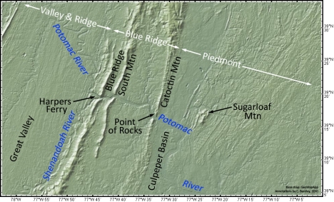
Sunday morning, NOVA adjunct geology instructor Chris Khourey and I went out to Sugarloaf Mountain, near Comus, Maryland, to poke around and assess the geology. Sugarloaf is so named because it’s “held up” by erosion-resistant quartzite. It’s often dubbed “the only mountain in the Piedmont,” which refers to the Piedmont physiographic province. Here’s a map, made with GeoMapApp and annotated by me, showing the general area:

A larger version of the map can be viewed by clicking here.

On the far west, you can see the Valley & Ridge province, which ends at the Blue Ridge Thrust Fault. Then the Blue Ridge province runs east from the Blue Ridge itself to Catoctin Mountain. From there, you enter the Piedmont, including both the “crystalline” Piedmont (Paleozoic metamorphism of various ocean basin protoliths, plus infusions of granite) and the Culpeper Basin, a Triassic/Jurassic rift valley. The Potomac River cuts a series of three spectacular water gaps across the Blue Ridge province just west of Sugarloaf. Harpers Ferry, West Virginia, is located at the confluence of the Potomac and the Shenandoah Rivers by the westernmost of these water gaps, and the name for the easternmost one is “Point of Rocks.”

Here’s a look at a detail from the southeastern corner of the geologic map of the Buckeystown, MD quadrangle, by Scott Southworth and David Brezinski:
sugarloaf_geol
sugarloaf_geol_key

The map pattern shows a that the area around Sugarloaf Mountain is a doubly-plunging anticlinorium of Sugarloaf Mountain Quartzite [SMQ] and overlying (younger) Urbana Formation. Overall, it’s got that typical “Appalachian” northeast-southwest trend. Notice the thrust fault on the west side: a typical hanging wall anticline? The ridges, including the summit of Sugarloaf Mountain itself, are held up by the toughest quartzite. This overall “squashed donut” shape shows up pretty well in the physiographic map up at the top of this post.

Sugarloaf is quartzite (metamorphic), but you can clearly see the sand grains that composed its protolith (sedimentary). There’s also reports of cross-bedding, and so Chris asked me to take a look at a few structures to assess them with my point of view. I found a pervasive cleavage in the rock, far more than I would have suspected would be there. We did find bedding exposed as compositional/grain size layers in several locations, including on the summit. I also paid a lot of attention to the many quartz veins which cut the metasedimentary quartzite. These veins of “milky quartz” are often arranged in lovely en echelon series, like these tension gashes:

tension_gash_array_sugarloaf_web

I took the above photo several years ago on a visit there, but it’s typical of the sorts of stuff we saw Sunday. The kinematic sense of this outcrop would be “top to the right.” Interestingly, none of the Sugarloaf outcrops show really deformed tension gashes (i.e., they’re not folded into Z or S shapes like those I showed you a few days ago).

What we really wanted to get a sense of, though, was which way was up in these rocks. We were in search of geopetal structures: primary sedimentary structures that indicate the “younging direction” of the beds. Graded beds can do this, though I didn’t see any unambiguous graded beds in the SMQ on Sunday’s trip. We wanted some cross-beds. We found some hummocky / swaley examples, looking approximately like this USGS photograph (black & white; hammer for scale) of an outcrop somewhere “north of the summit”:

crossbedding_USGS_sugarloafImage source: USGS

Ours wasn’t as beautiful as the one pictured above, but it was clearly hummocky cross-bedding, and it was right-side-up (in beds tilted at ~30°). Interestingly, the SMQ has been correlated by Southworth and Brezinski (2003) with the Weverton Formation of the Chilhowee Group, a rock unit exposed in the Blue Ridge. Just as the Weverton is overlain by the finer-grained Harpers Formation, so too is the SMQ overlain by a finer-grained unit, the Urbana Formation. Both are interpreted as metamorphosed continental margin deposits. The Urbana is mostly phyllite in the areas I’ve seen it (including phyllite that’s full of quartz grains, a first for me). The Urbana is well exposed in a creek-side outcrop north of Sugarloaf Mountain, and I took Chris there to show him the lovely intersection of bedding and cleavage.

Here is a weathered piece of the Urbana Formation that Chris collected there, looking at the plane of cleavage (ruler in background for scale):

urbana Image source: Christopher Khourey

You can see the bedding running ~horizontally across it, though the photo cannot convey the lovely phyllitic sheen that results from waggling these samples back and forth in good light. It’s pretty cool. In places, the transition from sandy to phyllitic is gradational, probably relict graded bedding.

So, what does it mean if Southworth and Brezinski (2003) are correct in their correlation, and the Weverton and the SMQ are really the same rock layer, but in different provinces and at different metamorphic grades? Recall that the Blue Ridge province to the west is also a thrust-faulted anticlinorium, launched up and to the west by the Alleghanian Orogeny from an original position deeper in the crust and further towards the east. It’s a shard of the craton, snapped off and shoved bodily up and to the northwest. (In class, I often liken it to Joe Theismann’s leg: a compound fracture of the continental crust.) Might the Sugarloaf Mountain Anticlinorium [SMA] be a smaller version of the Blue Ridge pulling the same trick? It too is arched up and snapped off …but it would be a “Mini-Me” that’s only just surfacing, like a baby whale swimming above momma whale’s back…

whales_analogy

We know that deeper down in the Blue Ridge stratigraphy, we find the Catoctin Formation, the Swift Run Formation, and the basement complex. If we drilled down through the crest of the SMA, would we find the same units (or more metamorphosed equivalents thereof)? It’s an intriguing thought…

Transect debrief 8: late brittle deformation

The final chapter in our Transect saga is now here. In some ways, it’s the least thrilling of the bunch. On the other hand, when I see a nice example of this structure, it makes me squeal like a little girl.

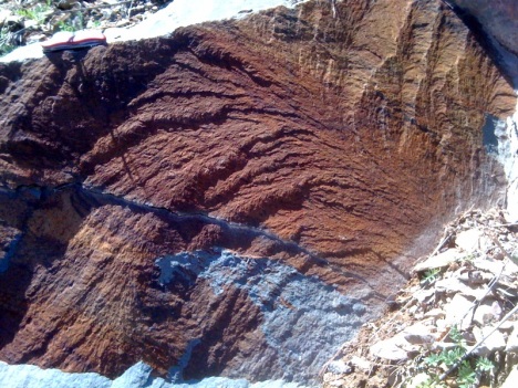
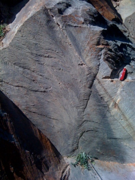
I refer, of course, to plumose structure, the small-scale architecture of a joint surface. We saw multiple great examples on the trip, but my favorites came with the first post-lunch stop on Transect Trip day #1, at an outcrop of the Weverton Formation showing a fine-grained deposit of siltstone.

I posted versions of both these photos previously via iPhone, but here I’ll give you the crisper Canon Elph version coupled with reposting of the iPhone shots for comparison purposes.

tt_11

tt_10

Plumose structure branches out in the joint propagation direction, the curvilinear “plumes” are thought to be perpendicular to the leading edge of the joint as it cracks through the rock. These late-stage brittle features may be related to the very latest part of Alleghanian deformation, or they may be related to recent uplift of these rocks.

All righty, then. I think that brings us up to the present day. Those of you who requested more details about the live-geoblogged photos, has this series answered your questions? If not, what do you need more details on?

Transect debrief 7: Brittle-ductile deformation

On the transect trip, I also saw some nice meso-scale “minor” structures that probably formed during Alleghanian deformation. Prominent among the ones that really impressed me were these en echelon tension gash arrays, deforming the Antietam Formation quartz sandstone and well exposed in blocks used to construct the wall along Skyline Drive and the Sandy Bottom Overlook in Shenandoah National Park:

tt_5

Good Lord! Ain’t those things beautiful? They also give us a lovely sense of the kinematics (relative motions) of the blocks of Antietam sandstone on either side of this sheared zone. In the case of the image above, the left side of the photo has moved “down” relative to the right side. The rock in between has torn and stretched, with the gashes opening up at right angles to the maximum stretching direction. As deformation proceeds, of course, the gashes rotate and deform, folding into “S” shapes.

Here’s one that’s more subtle:

tt_7

What you’re looking at in the image immediately above is a tension gash array that was a zone of weakness, exploited by later brittle deformation. The fracture which defines the edge of this block cracked through those old brittle-ductile tension gashes and split them clean in half.

Neat, eh? …Now check this out:

tt_9

Remember the Skolithos trace fossils? Here, you’re looking at a sideways cross section through some cylindrical Skolithos as they are disrupted by this zone of shearing. Note that the burrows tend to be highlighted by rust (hematite) staining: the brown lines that run roughly from the top left of the photo towards the bottom right. But look what happens to the orientation of those tubes where they are cut by the tension gash arrays: they are deflected into a new orientation, rotated from their original orientation!

If that’s a bunch of gobbledygook to you, consider this annotation:

tt_9_anno

I’ve drawn white lines to show the orientation of the Skolithos tubes in their undeformed and deformed states, colored the tension gashes yellow, and drawn on a set of blue arrows to show my kinematic interpretation (top to the left).

Here’s another block, showing the same phenomenon:

tt_8_anno2

Go ahead. Tell me you’re not impressed with that. I dare you. That is frakking AWESOME.

You are now dismissed.