Tavşanlı Zone field trip, part 3

Picking up where we left off last time, we were in some partly-serpentenized peridotite, part of the Burham Ophiolite in Turkey’s Tavşanlı Zone, an ancient tectonic suture.

Our next stop on the field trip allowed us to visit some diabase dikes:

tav_3_01

Here’s a close-up of the right contact of the dike with the host peridotite:

tav_3_02

The field notebook’s long edge is ~18 cm. And here it is again, annotated:

tav_3_02anno

Near the village of Oranheli, we stopped to examine a jadeite meta-granitoid, a rock only a metamorphic petrologist could love. There were, however, a lot of metamorphic petrologists on the trip, and they were very keen on checking it out. This was the first of many occasions when random Turkish citizens would stroll up to our odd group to find out just what the hell we were doing:

tav_3_03

Further along, we saw a meta-basite (meta-basalt) within the meta-granitoid, and there I got a refreshing whiff of structure. Here’s a random isoclinal fold of a meta-granitoid dike cross-cutting the meta-basite, with a Turkish 1-lira coin (about the same size as a U.S. quarter) for scale:

tav_3_04

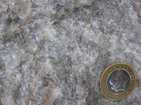
Next up were some very cool rocks: marbles with extremely elongated calcite crystals.

tav_3_05

These needle-like crystals are interpreted as being pseudomorphs of aragonite, the form of CaCO3 which is stable at high pressures and low temperatures.

tav_3_16

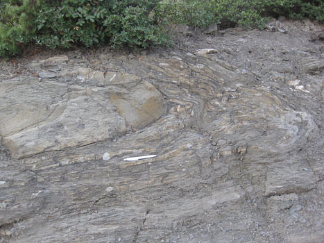
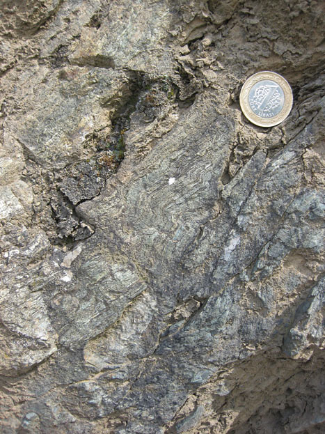
A bit further on, we return to metamorphosed shale and graywacke (now schist and “grayfels”), sheared out and pervasively deformed at blueschist conditions. I took a few photos of charismatic folds in the unit:

tav_3_09

Annotated, roughly showing the trace of foliation:

tav_3_09anno

Sandy layer folded over into a recumbent position, set in a sheared mass of meta-shale:

tav_3_06

Thicker sandy layer, in a recumbent isoclinal fold (white pen, 14 cm long, for scale):

tav_3_08

Zooming in on the above photo, to show the lovely, smaller wavelength parasitic folds which decorate the snout of the big fold:

tav_3_07

Extensional fractures along an isoclinally-folded, recumbent sandy layer:

tav_3_10

Small S-folds in the sheared shale (just above hammer):

tav_3_11

Coming down onto this roadside outcrop of sheared shale and graywacke were cobbles and boulders of float from somewhere up above. They were of a quartz-pebble conglomerate that showed a stretching lineation. Check out these two faces of typical samples:

tav_3_14

tav_3_15

Now, here they are again, with the X, Y, and Z axes of the strain ellipsoid (longest, intermediate, and shortest, respectively) labeled for your benefit.

tav_3_14anno

tav_3_15anno

This conglomerate has been sheared into a lovely L-S tectonite, with X>Y~Z. In other words, it’s mostly lineated, with only a weakly-defined foliation, indicating the stress field was mostly constrictional. (I collected a muddy sample of this stretched-pebble meta-conglomerate, and when I washed it off in the hotel shower the next morning, I was delighted what a cool sample I had selected. It has some awesome structural features; I’ll show it to you some other time…)

Our final stop of Day 1 of the trip was this spectacular overview of the Kocasu Gorge, a canyon which cuts across the structural trend of the area at approximately a right angle. (The canyon cuts north-south; the strike of the folded & thrusted rock units runs approximately east-west.)

tav_3_13

As the sun set, Aral showed us where we were, and the overall synclinal structure of the area.

tav_3_12

I recorded it in my field notebook like this:

kocasu

With this context established, we loaded back on the bus and drove for a couple of hours to get to a town with a decent hotel. We dined and slept, and the next morning got up ready for more suture-zone rocks.

Tavşanlı Zone field trip, part 2

Yesterday, I shared a few thoughts about the first couple of stops on the field trip I took earlier this month from Istanbul to Ankara, prior to the Tectonic Crossroads conference. Today, we’ll pick up with some images and descriptions from the next few stops.

After lunch, our next stop brought us to a relatively low-metamorphic-grade outcrop of sheared graywacke (dirty sandstone) and shale. As you can imagine, it wasn’t particularly photogenic. Bedding was continuous only over a scale of a meter or two. It’s what suture-zone workers call “broken formation,” part way between undeformed rocks and a full-blown mélange. (It’s internally sheared up, but not yet mixed with adjacent formations.)

Looking back the way we had driven in, though (i.e., looking to the north), we could see the west-ward dipping limb of a large syncline exposed on the mountainside over yonder:

tav_1_08

Annotated version:

tav_1_08anno

The Orhanler Formation is the lowermost unit, layers of graywacke and shale that are probably Triassic in age. It is overlain by the thin sandstones of the Bayırköy Formation (Liassic), and then the limestone which is proving so irresistible to quarry excavators, the upper Jurassic Bilecik Limestone.

Our fourth stop was one of the ones that got me really excited. In fact, almost everyone on the trip seemed to get pumped up from visiting this outcrop. Check it out:

tav_2_01

The yellow field notebook’s long edge measures ~18 cm. Behind the notebook, my friends, is a layered gabbro. The stripes you see result from differing ratios of light and dark colored minerals — plagioclase and pyroxene, mainly. But why is it layered? Is this an example of a cumulate texture; a primary igneous structure resulting from the settling of crystals onto the floor of a magma chamber? Or is this a tectonic foliation, resulting from strain the rock has accumulated? It was introduced to the participants on the field trip as an example of the former, but several of us found this argument less than totally convincing, as the size of this rock body is ~200 km long and ~2 km thick. It’s awfully hard to envision a magma body that size. I found it easier to imagine this as a chunk of the mantle, as Alain Tremblay suggested to the group.

As I poked around the outcrop, I found something which was consistent with a deformational (rather than cumulate) origin to the layering…

tav_2_07

That’s an S-fold! Turn this cobble around, and on the other side, you can see a Z-fold:

tav_2_08

I suppose that tight little folds like this could have come in some stage of ductile deformation after an original cumulate layer formed, but that would require an episode of deformation not required by the foliation hypothesis. If these are planes formed by mantle flow, I’d expect a few small folds in those layers at the time that flow was forming them. Besides the blueschists and eclogites, the Tavşanlı Zone includes an ophiolitic suite, and having chunks of mantle there would in no way be a shocker.

Regardless of the origin of the mineralogical layering, I think we can all be pleased to learn that it is deformed. A series of “reverse” ductile shear zones cut across the layering, as you may be able to discern in this photo:

tav_2_02

Notice how the gabbro’s layers deflect towards the fault(s) in a “drag fold” fashion, tipping over to the left. Close up:

tav_2_03

Left of the notebook, you can see this gentle deflection quite nicely:

tav_2_04

This is sweet, right? I’m loving it.

tav_2_05

A close-up shot that particularly satisfies me:

tav_2_06

Note the thinning and rotation of the mineralogical layers as you get closer to the shear band at the center of the shear zone itself (far right of photo). Pen for scale.

We also stopped at a proper peridotite outcrop (no one’s arguing that this one isn’t mantle), which had serpentine veins cutting though it:

tav_2_09

More later

By the way, this blog’s move to the AGU servers has been postponed until probably Monday.

Tavşanlı Zone field trip, part 1

Before the Tectonic Crossroads conference two weeks ago, I had the good fortune to participate in a Istanbul-to-Ankara geology field examining the Tavşanlı Zone, a tectonic suture zone where a portion of the Tethys Ocean basin closed. This paleo-convergent boundary is marked by a suite of interesting rocks, including blueschists, ophiolites, and eclogites. I’d like to share with you some of the things I saw along the trip.

This is one of the trip leaders, Aral Okay (pronounced “Oh-kai,” okay?), discussing the general geology of the area at our first stop. (The other trip leader was Donna Whitney.)

tav_1_01

I think in general, you can make out the east-west trend of the rock units on Aral’s map (where they aren’t obscured by alluvium). This reflects the approximate north-south convergence of the Tethys closure in Turkey. To visualize this, I’d like to call your attention to a paleogeographic interpretation of the Tethys Ocean from Ron Blakey, the talented mapmaker from Northern Arizona University:

tethys

See all those colliding east-west-oriented crustal fragments in the northwestern Tethys? Those are the pieces that will comprise future Turkey. As you can imagine, rocks caught up in these tectonic collisions got both deformed and metamorphosed. Some of them were even subducted to ~80 km depth, and then brought back up to the surface! At our first stop, we saw some blueschist-grade rocks that had a phyllitic texture. Here’s two of them:

tav_1_02

As usual, my eye was drawn towards the structures visible in these rocks. Here are a couple of nice little folds:

tav_1_03

tav_1_05

(The Turkish 1-lira coin is the same size as a U.S. quarter.)

I found this to be an interesting portion of the outcrop:

tav_1_04

That’s green phyllite on the left, and blue phyllite on the right. Allow me to annotate it for you:

tav_1_04anno

“Blueschist” and “greenschist” refer to two assemblages of minerals which supposedly represent different combinations of temperature and pressure. They are examples of metamorphic “facies,” as illustrated in this image:

facies

Image redrawn and modified by me from Figure 3 of Bousquet, et al. (2008), which is itself modified from Oberhänsli, et al. (2004), and also from University of British Columbia (1997), which is modified from Yardley (1988).

Theoretically, blueschists and greenschists should be forming at different combinations of pressure and temperature. Blueschist forms at high pressures, but relatively low temperatures. But here we have an outcrop of blueschist that is right adjacent to a greenschist (medium temperature and pressure), with no faulting in between. It was suggested to me by a blueschist expert that this was likely a reflection in differences in the initial composition of the protoliths. I found this explanation less than completely satisfying, but there was no time to discuss, for we were being called back to the bus, already gunning its engine and ready to roll down the road.

At our second stop, we found some metamorphic rocks that showed clear textural evidence of having had pyroclastic protoliths:

tav_1_06

There were lots of chunky bits in there.

tav_1_07

So it wasn’t just pelitic (muddy) rocks that were getting metamorphosed in this Tethyan suture zone, but volcanic rocks too!

More later… when we move on to stop #3

Rumeli Hisarı

Right after I got to Istanbul on this most recent trip, I took a taxi from my hotel down to the Bosphorus, to check out the Rumeli Hisarı, a fort complex built in 1452 by Sultan Mehmet the II in anticipation of the following year’s siege of Constantinople. It’s constructed at the narrowest point on the Bosphorus (660 m wide), with the aim of controlling boat traffic coming from the Black Sea. This narrow spot is today where they have the second of two bridges spanning the Bosphorus. It looks like this:

rumelihisari08

It’s in Europe; that’s Asia on the far right of the photo. A few more shots of the fortress’s pattern of towers and interconnecting walls:

rumelihisari04

rumelihisari05

rumelihisari01

Inside, I was pleased to note the variety of building stones. Here’s a nice porphyritic andesite which was a common constituent of the walls:
rumelihisari02

And a folded limestone:

rumelihisari06

Here are some yellowish blocks that are weathering away faster than the mortar which holds them in place. There is a Turkish 1-lira coin in front of the dark block near the center, to provide a sense of scale:

rumelihisari11

Here’s a similar phenomenon playing out with some bricks used to make an archway, except here the mortar is the more rapidly weathering component:

rumelihisari07

Check out this slab of brick… it’s got a curious adornment:

rumelihisari10

Zoomed in to show this detail:

rumelihisari09

Dog prints! Sometime a long time ago, maybe more than 500 years ago, a brick maker put out slabs of clay to dry, and some long-dead dog walked across it. The dog’s footprints are a kind of “historical trace fossil” that was then incorporated into this ancient structure.

Visiting the Rumeli Hisarı was a pleasant experience. I walked down along the Bosphorus next, peering into its surprisingly clear waters and counting jellyfish, then got a pide at a cafe. I caught another cab back to the hotel, and eventually fell asleep, a victim of jet lag…

rumelihisari03

Güvem geoheritage site, Turkey

Looks like I’m late to the party…

While I was away, apparently the geoblogosphere went on a rampage of cooling columns. Everyone was posting images of their favorite columnar joints, and I was left out in the cold. Let me remedy that now. As it turns out, I was visiting some columns while everyone else was writing about them. Here are some images from the Güvem area of Turkey, north of Ankara, where there are a mix of late Miocene lake sediments and intercalated volcanic rocks, including these basalt flows. We stopped to visit them last Wednesday on our way to the North Anatolian Fault:

guvem_columns11

The dark entablature looms above:guvem_columns01

A nice central panel with a good cross-section of the flow: guvem_columns03

Around the corner, some more:
guvem_columns04

I ran across the street (and a stream) to check out a similar exposure there:guvem_columns05

Zooming in:guvem_columns06

Close-up of a few columns (with my hand for scale):guvem_columns08

Looking up along the columns:guvem_columns09

And a few more shots of the scene:guvem_columns10

guvem_columns02

A full list of Turkish geoheritage sites may be found at the end of this document. Lockwood maintained a list of the other blog posts in this meme here, which I’ll quote below since it’s so nicely laid out already:

Geotripper, here, here and here,
Sam at Geology Blues
Phillip, also at Geology Blues
Silver Fox, and another columnar post here.
Glacial Till and another!
Life in Plane Light: Squashed columns!
Aaron at Got The Time
Geology Rocks
Dana at En Tequila Es Verdad
Cujo 359 (see comment on Dana’s post for description)
Wayne at Earthly Musings has a gorgeous photo of columns below the rapids at Lava Falls in Grand Canyon.
MB Griggs at The Rocks Know has photos of what may well be the most perfect columns in the world.
Jessica, AKA Tuff Cookie, showcases a variety in different rock types.
Hypocentre finds columns in a very unlikely place, as well as a spectacular photo of radiating columns.
Dave Tucker at Northwest Geology Field Trips displays precisely one slew of columnar displays in Washington State.
Dave Bressan at History of Geology shares the first printed image of columnar basalts, from 1565.
A couple more variations from Dana’s and my driving about W. Oregon.
Dr. Jerque has some spectacular examples from the bottom of the Grand Canyon.
Silver Fox Has another (better than mine) photo of horizontal columns in a set of dikes, and points out a couple more links to columny goodness (not to be confused with calumny, which is not good)
Dan McShane offers some more Washington State columns.
Garry Hayes, who deserves credit for starting this meme (see first links in the list, above), adds yet another set of photos from the opening of the Atlantic Ocean, and a lovely guest photo by Ivan Ivanyvienen, of columnar jointing in rhyolite at the San Juan Precordillera.
Update, October 4: Eric Klemetti- who did his doctoral work just down the street from where I’m sitting- has joined the fray. (Also, check out the links readers have left in the comments)
Helena Heliotrope at Liberty, Equality and Geology shows off some more Washington columns.
Chris and Anne at Highly Allochthonous each toss in a photo- Tokatee Falls looks awesome!
Some more Cape Perpetua jointed dike photos from Cujo359, and Devil’s Churn– again, numerous dikes with horizontal columns.

Two xenoliths

On my last day in Ankara Turkey (last Friday), I took the afternoon off from the Tectonic Crossroads conference in order to pay the requisite visit to the Museum of Anatolian Civilizations. I say “requisite” because Ankara’s not quite so thrilling a town as Istanbul, but this is the one location that everyone agrees is worth a visit. The previous day at breakfast in our hotel, University of Georgia geology professor Jim Wright told me it was the most amazing place he had ever seen. So I had to go check it out for myself.

It’s a cool place, if you’re into history. Anatolia (the Asian part of Turkey, which is to say, most of Turkey) is a place steeped in history. Their written records go back 9000 years, if you include Neolithic cave paintings. It’s pretty neat to check out their sculptures and tools over that long span of time. (See some photos here.)

I only took one picture in the museum, though. This is it:

xeno_1

That’s a Hittite lion sculpture made of porphyritic andesite. I took his portrait because of that funny looking eyebrow — that’s a little black xenolith, a chunk of pre-existing solid rock that got stoped off the wall rock and carried along in the flow of magma, eventually getting trapped in “alien” territory once the magma (or lava) solidified around it into rock. It was the most striking geological aspect of the museum’s many displays.

After I got “museumed out” (usually this takes about 2 hours), I went for a walk around the adjacent “Citadel” region of old town Ankara, and what do you know, but I found an outcrop there! Not only that, but there were some striking similarities to the photo I had just taken in the museum — it was a porphyritic volcanic rock (I want to call it a rhyolite based on the pink color), and it too had a lone dark xenolith:

xeno_2

A little girl wandered up to me with unabashed curiosity — why was this foreigner putting a lira coin on the rock and taking a photo of it in the rain? Plainly, I must be insane. I greeted her, pocketed my coin, and strolled on, reflecting on the satisfaction of seeing such a nice little pairing of similar structures in similar rocks — a quarter mile from one another, though in very different settings.

Leftovers*

Today I’m in the air, on my way back to Turkey for the Tectonic Crossroads conference being held in Ankara next week. Before the meeting, I’m joining a field trip to examine a subduction zone complex. Over three days, we will drive from Istanbul to Ankara by way of ophiolites and blueschists and other geologic wonders. I’m excited. Hopefully I’ll be able to post an update or two from Turkey, but I don’t know what my internet access will be there. I’ve also got a couple of short pieces in the pipeline to post automatically, so you won’t go into withdrawal while I am out of town.

__________________________

* Get it, like it’s my second time sampling the flavors of Turkey? “Leftovers?” Like the day after Thanksgiving? …Funny, right? …Right?

An unfortunate name

I’ll bet this Turkish children’s clothing company really wishes they had gone with something else for their name…
ufukbebe

Yikes.

Building stones of the Haghia Sophia

The Haghia Sophia (or “Ayasophia”) is an astounding building in old town Istanbul. It is an ancient cathedral turned mosque turned museum. Through all these incarnations, the Hagia Sophia has retained some features and had other ones added on: it is a palimpsest of architecture, symbology, and history. Walking through its soaring main chamber, or side passages and alcoves, visitors like me stand with necks bent and mouths agape. It is an unparalleled location for peeling back the layers of time.

Built in 532 CE by the Emperor Justinian, the cathedral rose on the same spot where two earlier churches had stood, the first of which was built in 360 CE. The name “Haghia Sophia” comes from the Greek for “holy wisdom.” For more than a thousand years, it served as the principal church of the Byzantine Empire. It was the world’s largest cathedral for thousands of years. The minarets were tacked on in 1453, after Constantinople fell to the Ottoman Empire:

istanbul03

There’s a gazillion aspects of this building to discuss, but today I’d just like to share some images of the different building stones seen in and around the Haghia Sophia. To start with, here’s a “Verde Antique” (serpentenite breccia) sarcophagus outside the building:

istanbul02

The floor stones in an interior hallway, worn smooth and shiny by millennia of human shuffling:
Haghia06

And a bunch of shots of stones used in the interior walls …

Granite (verging on unakite?):

istanbul04

Conglomerate:

istanbul05

Rhyolite porphyry:

HaghiaSophia_02

Rhyolite porphyry with xenoliths (also used to construct a sarcophagus outside):

istanbul06

Marble gneiss:

istanbul07

Darker granitoid:

istanbul08

There are also some structurally interesting rocks, like this red and white marble breccia that shows pressure solution. Notice the sutured boundaries of the white grains, and their pronounced long axes, 90° to that maximum pressure direction.
HaghiaSophia_03

Kind of reminds you of the Purgatory Conglomerate, right? (Me too.)

My favorite rock there is this lurid, gory red/white/black marble gneiss, as it displays ptygmatic folding (elsewhere it is also boudinaged):
Haghia07

I wish I had more photos of this stuff. It’s great. It reminds me of guts!

Here it is in a typical display (pardon the blurriness of the photo): they “fillet” the rock and spread it open in the manner of a Rorschach blot. This produces an attractive symmetrical design, with minimal artistic effort:
haghia_A

Another nice “butterfly” spread, this one of folded marble gneiss:
Haghia01

Another one:
Haghia08
Look close at this one. Note the little gray crosses in there? Let’s zoom in…

Here’s one closer-up:

Haghia10

These are ancient Christian crosses, or rather, the holes where ancient Christian crosses were once mounted on the wall. When the Haghia Sophia was converted to a mosque in 1453, these Christian symbols were removed, and the holes cemented over to obliterate traces of the old religion. Here’s another one, where the cement has fallen away:

Haghia09

Along similar lines, here’s some Arabic script carved into the railing of the second floor, marring a lovely marble breccia:
HaghiaSophia_01

Stuff like this just floors me. I mean, think about all the different people to lean on this railing over the past 1500 years. The Haghia Sophia’s history is so deep, with so many distinct overlapping layers. The mind reels…

A fantastic concentration of building stones may be found at the “Coronation” spot on the main floor of the building, where Byzantine kings were crowned:

Haghia05

Haghia04

Haghia03

Haghia02

Haghia_B

After several pleasant hours touring the Haghia Sophia, we got lunch at a great cafe nearby. Lily got lentil soup:

istanbul21

…and I got an amazing pide, the Turkish style of “pizza”:

istanbul22

Delicious rocks followed by delicious repast! Can’t complain…

The Blue Mosque

In Istanbul over the summer, Lily and I checked out the “Blue Mosque,” named for the predominant color of the mosaic tiles in its interior. It’s more formally know as “Sultan Ahmed Mosque,” named for the sultan who commissioned its construction in 1609. It is an elegant building:

istanbul12

I loved the “pile of bubbles” effect of the multiple domes, and then the skyward piercing forms of the minarets.

istanbul10

It also cuts an impressive silhouette at night:
istanbul23

The mosque is open to the public, including tourists. To visit it, you are asked to remove your shoes. Women are asked to cover their hair. Here’s Lily in the appropriate garb:

istanbul13

I was shocked to see how many tourists completely ignored this request, whether out of contempt for the fact that Islam treats men and women differently, or out of sheer cluelessness. I’m no fuddy-duddy, but it seems to me that when you’re visiting a house of worship, you should follow the requests of the host faith.

Once inside, we got a look at the tiles for which the place is named:

istanbul17

There were some interesting uses of building stones. Consider this arch, made of alternating blocks of conglomerate and marble gneiss:

istanbul16

The ceiling of the Blue Mosque soars high above, decorated with more tiles:

istanbul15

An ugly addition to this elegant architecture is a rack of lights, loftily called a “chandelier,” suspended on long cables. I thought this modern tack-on was rather tacky, but I guess it makes prayer easier in the dark hours:

istanbul01

The ceiling is held up by four enormous pillars; many architectural critics find these ungainly and obtrusive:

istanbul14

After our visit, we went to get some traditional Turkish tea at a little place overlooking the Bosphorus. The tea is very sweet, but comes with extra sugar cubes regardless:

istanbul11

Here’s the view of the Bosphorus, the straight separating European Istanbul from Asian Istanbul. You’re looking north in this photo, with Europe on the left, and Asia on the right:

istanbul09