Tavşanlı Zone field trip, part 3

Picking up where we left off last time, we were in some partly-serpentenized peridotite, part of the Burham Ophiolite in Turkey’s Tavşanlı Zone, an ancient tectonic suture.

Our next stop on the field trip allowed us to visit some diabase dikes:

tav_3_01

Here’s a close-up of the right contact of the dike with the host peridotite:

tav_3_02

The field notebook’s long edge is ~18 cm. And here it is again, annotated:

tav_3_02anno

Near the village of Oranheli, we stopped to examine a jadeite meta-granitoid, a rock only a metamorphic petrologist could love. There were, however, a lot of metamorphic petrologists on the trip, and they were very keen on checking it out. This was the first of many occasions when random Turkish citizens would stroll up to our odd group to find out just what the hell we were doing:

tav_3_03

Further along, we saw a meta-basite (meta-basalt) within the meta-granitoid, and there I got a refreshing whiff of structure. Here’s a random isoclinal fold of a meta-granitoid dike cross-cutting the meta-basite, with a Turkish 1-lira coin (about the same size as a U.S. quarter) for scale:

tav_3_04

Next up were some very cool rocks: marbles with extremely elongated calcite crystals.

tav_3_05

These needle-like crystals are interpreted as being pseudomorphs of aragonite, the form of CaCO3 which is stable at high pressures and low temperatures.

tav_3_16

A bit further on, we return to metamorphosed shale and graywacke (now schist and “grayfels”), sheared out and pervasively deformed at blueschist conditions. I took a few photos of charismatic folds in the unit:

tav_3_09

Annotated, roughly showing the trace of foliation:

tav_3_09anno

Sandy layer folded over into a recumbent position, set in a sheared mass of meta-shale:

tav_3_06

Thicker sandy layer, in a recumbent isoclinal fold (white pen, 14 cm long, for scale):

tav_3_08

Zooming in on the above photo, to show the lovely, smaller wavelength parasitic folds which decorate the snout of the big fold:

tav_3_07

Extensional fractures along an isoclinally-folded, recumbent sandy layer:

tav_3_10

Small S-folds in the sheared shale (just above hammer):

tav_3_11

Coming down onto this roadside outcrop of sheared shale and graywacke were cobbles and boulders of float from somewhere up above. They were of a quartz-pebble conglomerate that showed a stretching lineation. Check out these two faces of typical samples:

tav_3_14

tav_3_15

Now, here they are again, with the X, Y, and Z axes of the strain ellipsoid (longest, intermediate, and shortest, respectively) labeled for your benefit.

tav_3_14anno

tav_3_15anno

This conglomerate has been sheared into a lovely L-S tectonite, with X>Y~Z. In other words, it’s mostly lineated, with only a weakly-defined foliation, indicating the stress field was mostly constrictional. (I collected a muddy sample of this stretched-pebble meta-conglomerate, and when I washed it off in the hotel shower the next morning, I was delighted what a cool sample I had selected. It has some awesome structural features; I’ll show it to you some other time…)

Our final stop of Day 1 of the trip was this spectacular overview of the Kocasu Gorge, a canyon which cuts across the structural trend of the area at approximately a right angle. (The canyon cuts north-south; the strike of the folded & thrusted rock units runs approximately east-west.)

tav_3_13

As the sun set, Aral showed us where we were, and the overall synclinal structure of the area.

tav_3_12

I recorded it in my field notebook like this:

kocasu

With this context established, we loaded back on the bus and drove for a couple of hours to get to a town with a decent hotel. We dined and slept, and the next morning got up ready for more suture-zone rocks.

Tavşanlı Zone field trip, part 1

Before the Tectonic Crossroads conference two weeks ago, I had the good fortune to participate in a Istanbul-to-Ankara geology field examining the Tavşanlı Zone, a tectonic suture zone where a portion of the Tethys Ocean basin closed. This paleo-convergent boundary is marked by a suite of interesting rocks, including blueschists, ophiolites, and eclogites. I’d like to share with you some of the things I saw along the trip.

This is one of the trip leaders, Aral Okay (pronounced “Oh-kai,” okay?), discussing the general geology of the area at our first stop. (The other trip leader was Donna Whitney.)

tav_1_01

I think in general, you can make out the east-west trend of the rock units on Aral’s map (where they aren’t obscured by alluvium). This reflects the approximate north-south convergence of the Tethys closure in Turkey. To visualize this, I’d like to call your attention to a paleogeographic interpretation of the Tethys Ocean from Ron Blakey, the talented mapmaker from Northern Arizona University:

tethys

See all those colliding east-west-oriented crustal fragments in the northwestern Tethys? Those are the pieces that will comprise future Turkey. As you can imagine, rocks caught up in these tectonic collisions got both deformed and metamorphosed. Some of them were even subducted to ~80 km depth, and then brought back up to the surface! At our first stop, we saw some blueschist-grade rocks that had a phyllitic texture. Here’s two of them:

tav_1_02

As usual, my eye was drawn towards the structures visible in these rocks. Here are a couple of nice little folds:

tav_1_03

tav_1_05

(The Turkish 1-lira coin is the same size as a U.S. quarter.)

I found this to be an interesting portion of the outcrop:

tav_1_04

That’s green phyllite on the left, and blue phyllite on the right. Allow me to annotate it for you:

tav_1_04anno

“Blueschist” and “greenschist” refer to two assemblages of minerals which supposedly represent different combinations of temperature and pressure. They are examples of metamorphic “facies,” as illustrated in this image:

facies

Image redrawn and modified by me from Figure 3 of Bousquet, et al. (2008), which is itself modified from Oberhänsli, et al. (2004), and also from University of British Columbia (1997), which is modified from Yardley (1988).

Theoretically, blueschists and greenschists should be forming at different combinations of pressure and temperature. Blueschist forms at high pressures, but relatively low temperatures. But here we have an outcrop of blueschist that is right adjacent to a greenschist (medium temperature and pressure), with no faulting in between. It was suggested to me by a blueschist expert that this was likely a reflection in differences in the initial composition of the protoliths. I found this explanation less than completely satisfying, but there was no time to discuss, for we were being called back to the bus, already gunning its engine and ready to roll down the road.

At our second stop, we found some metamorphic rocks that showed clear textural evidence of having had pyroclastic protoliths:

tav_1_06

There were lots of chunky bits in there.

tav_1_07

So it wasn’t just pelitic (muddy) rocks that were getting metamorphosed in this Tethyan suture zone, but volcanic rocks too!

More later… when we move on to stop #3

Photos from Virginia Geological Field Conference

For the second year in a row, more exotic travel plans meant that I wasn’t able to attend the superb Virginia Geological Field Conference. I see that they have now posted some photos on the group’s Facebook page, so go check them out to see what we both missed last weekend. Here’s a taste:

Sheared meta-conglomerate:

Metamorphosed mantle (?) xenoliths:

Friday fold: Archean gneiss from Montana

Leftovers*

Today I’m in the air, on my way back to Turkey for the Tectonic Crossroads conference being held in Ankara next week. Before the meeting, I’m joining a field trip to examine a subduction zone complex. Over three days, we will drive from Istanbul to Ankara by way of ophiolites and blueschists and other geologic wonders. I’m excited. Hopefully I’ll be able to post an update or two from Turkey, but I don’t know what my internet access will be there. I’ve also got a couple of short pieces in the pipeline to post automatically, so you won’t go into withdrawal while I am out of town.

__________________________

* Get it, like it’s my second time sampling the flavors of Turkey? “Leftovers?” Like the day after Thanksgiving? …Funny, right? …Right?

Another metamorphosed graded bed

Over the summer, when my blogging access was limited to my iPhone, I uploaded a photo (taken with the iPhone) of a metamorphosed graded bed on the summit of Mount Washington, New Hampshire.

Here’s another one that I saw, further down on the mountain, on the Auto Road (famous for its iconic bumper sticker):

Lens cap for scale. …And here’s the obligatory annotated copy:

Both of these images are enlargeable by clicking through (twice).

I think today’s photos are of better quality than the iPhone photo. This is the coolest freakin’ thing ever. What you have here are alternating beds of quartzite and andalusite schist. The boundaries between the two rock units are alternately crisp and gradational. Interpretation? Once upon a time, you had a turbidite sequence where the bigger, heavier grains (quartz sand) settled out first, followed by progressively finer and finer mud. The base of the graded bed is a crisp transition from mud to sand, but then as you go up through the graded bed, it grades from sand into mud.

Later, these distinctive primary structures were metamorphosed during the late Devonian-aged east coast mountain building episode called the Acadian Orogeny. The high temperatures and pressures cooked the rock. The sandy part, dominated by quartz, didn’t really change mineralogy much under the metamorphic conditions. The muddy part, on the other hand, was chock full of clay minerals which are not in equilibrium under elevated temperatures and pressures, so they reacted chemically. Their elements reorganized into new minerals: big honkin’ crystals of the mineral andalusite. They might just as well have reorganized into sillimanite or kyanite if conditions were slightly different, but temperature dominated over pressure, so andalusite was the mineral form that was stable (at equilibrium) under those conditions.

As a result, the “mud” was now coarser grained than the “sand.” The overall sense of grading had been flipped by the metamorphosis, yet the overall crisp/gradual pattern was preserved. This, my friends, is exquisite.

Metamorphosed graded bed

This is the coolest thing I’ve seen this week: a graded bed metamorphosed via Acadian mountain building:

The graded bed starts at the Swiss army knife at left, where you see an abrupt transition between coarse grained metamorphic porphyroblasts (“pseudo-andalusites”) and finer grained quartzite. This was once a mud to sand transition when these were loose sediments in the Kronos Sea, but with elevated temperature and pressure, the clay minerals in the mud reacted to grow elegant porphyroblasts of andalusite and sillimanite. The sand was made of quartz: less reactive stuff, and all it did was fuse together when metamorphosed. I love this: the coarse to fine relationship in the original graded bed is flipped on it’s head by metamorphism. Follow the bed “up” (to the right), and you will see the quartzite grade into andalusite-dominated former mudstone. Pretty sweet, eh?

This example is from the summit area of Mount Washington, New Hampshire. More fun stuff when I get back to my home computer next Monday.

S-C fabric in meta-ignimbrite

Here’s a sample from my 2004 geology M.S. thesis work in the Sierra Crest Shear Zone of eastern California. The rock is a sheared ignimbrite (ashflow tuff) tuff bearing a porphyritic texture and a nicely-developed “S-C” fabric.

With annotations, showing the S- and C-surfaces, and my kinematic interpretation:

S-C fabrics develop in transpressional shear zones: ~tabular zones of rock that are subjected both to compression and lateral shear (“transform” motion). The S-surfaces (foliation) initially form at about 45° to the shear zone boundary, and then progressively tilt over in the direction of shearing as deformation proceeds. This gives this sample (when viewed from this angle) a dextral (top to the right) sense of shear. (previous examples on Mountain Beltway) The C-surfaces are shear bands, where a large amount of shear strain (parallel to the shear zone boundary) is accommodated.

You should be able to click through (twice) for big versions of these images.

I polished up this little slab and made a refrigerator magnet out of it. I think it’s a lovely rock.

“Those aren’t pillows!”

In the 1987 comedy Planes, Trains, and Automobiles, John Candy and Steve Martin have a funny experience. It involves a cozy hotel room (one bed only) and the two travelers are huddled up for warmth. As he wakes up, John Candy thinks he is warming his hand “between two pillows.” At hearing this, Steve Martin’s eyes pop wide open, and he yells, “Those aren’t pillows!”

They jump up, totally discombobulated. An awkward moment follows.

Well, it’s not quite as awkward, but I had a similar “those aren’t pillows” moment recently. I was out in Shenandoah National Park with my GMU structural geology students, and we stopped off at the Little Stony Man parking area (milepost 39.1 on Skyline Drive). Here’s a figure showing the area in question, from Lukert & Mitra (1986):

You’ll note in the detail map at the right that it shows the nonconformable contact that separates the basement complex (here, the “Pedlar” Formation) from the overlying metabasalts of the Catoctin Formation.You’ll also note that it says “PILLOWS” with an arrow pointing at a specific spot on the trail. The word refers to basaltic pillows, which are breadloaf-shaped primary volcanic structures that form when lava erupts underwater. They are typically the size of a bedroom pillow (especially overstuffed pillows). Here’s some video of pillows erupting.

Pillows have been reported elsewhere in the Catoctin (e.g., near Lynchburg, according to Spencer, Bowring, and Bell, 1989), but this is the only location that I’m aware of where they have been reported in northern Virginia. The implications are not all that tremendous: just that a portion of the Catoctin erupted subaqueously, but it would be a neat thing to show students, especially seeing how close the outcrop is to safe parking.

Well, I’ve been to this area a half-dozen times, and I’ve never been able to find those damn pillows. It’s frustrated me, but I had an additional impetus this time around: I ran into Jodie Hayob, the petrology professor from Mary Washington University, who was out there with her students for the day. First thing we said to one another? You guessed it: “Did you find the pillows?”

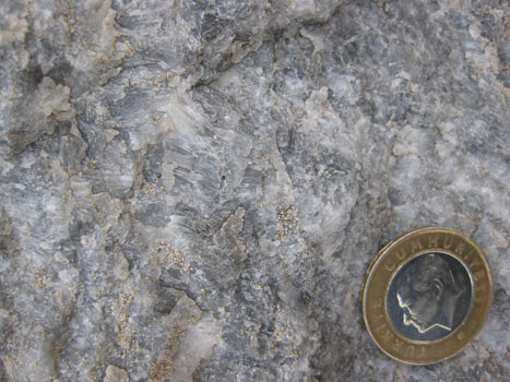
While the students ate their lunches, I went off downhill (to the west), exploring and looking for these confounded pillows. Pretty soon, I found something that looked vaguely pillowy, at least in terms of have a well-defined “crust” with a dark interior (click through that link for a fine Canadian pillow, courtesy of Ron Schott). Prepare yourself for a lot of photos today… Here’s what I saw:

not_pillow_01

A few meters further downhill, I found another outcrop of the same stuff, this one veiled in a thin layer of algae (ahh, the joys of east coast geology!):

not_pillow_02

Little double-ridges which varied in parallel, defining small chunks of rock. Could these be the fabled pillows? But they’re …so small! They’re almost pincushions! I know they say size doesn’t matter, but it’s hard for me to picture a volume of lava this small hitting water and “inflating” to such a puny volume with a nice quenched glassy rind, but then having the interior to stay hot enough to crystallize into basalt. Hmmm. Starting to think something’s fishy with this subaqueous tale…

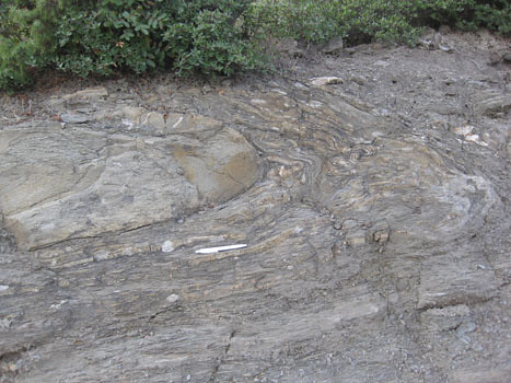
I then found a nice big cliff, 10 meters high and 20 meters wide, which was made of almost nothing but these structures. Here’s some of them highlighted by the sun (the boundary ridges weather out in high relief), despite being obscured beneath several layers of lichen:

not_pillow_03

not_pillow_04

A relatively clean, but relatively unweathered sample:

not_pillow_05

Aha, now that’s better:

not_pillow_06

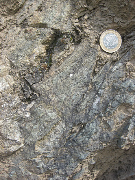
The next two show more of a “classic” Catoctin coloring: chlorite green when fresh, with buff weathered surfaces on the outside:

not_pillow_07

Zooming in on one small, skinny purported “pillow”:

not_pillow_08

I climbed back up and coerced some students into joining me to check these weird things out, and they clambered down. Danny W. found a nice chunk of float which showed one of the “pillows” in three dimensions. Check it out at the top of this sample:

not_pillow_09

Three-dimensional extension courtesy of Photoshop; red line shows the long axis of this oblate ~ellipsoid plunging towards the camera. (Lara laughs in the background…)

not_pillow_09_anno

Okay; two more… Check out how angular the boundaries of these “pillows” are:

not_pillow_11

Seeing this one really made me think: No way; “those aren’t pillows!“…

not_pillow_10

…Seeing that angular “break” on the left led me to realize that not only are these things too small* to be pillows, they also don’t have the right shape. Instead of being “pillowy,” (i.e., round) they are very angular, defined by edges that are aligned in a common direction and continue from one to the next.

* Where “too small” is defined as “smaller than anything Callan has seen before.”

I sketched in some of these planar edges:

not_pillow_10_anno

To me, it looks like what’s happening here is that original homogeneous rock of the Catoctin Formation fractured, and then fluids flowed along those fractures, altering the rock that the fluids came into direct contact with. This produced the “double ridge” of buff-colored rock (on either side of the fracture), with the less-altered greenstone interiors being beyond the reach of these altering fluids. The intersection of the various joints and their subsequent boundary-defining alteration would look something like this example (from the online structure photo collection of Ben van der Pluijm): definitely click through to check it out.

In other words, I interpret these structures to be secondary, not primary. The end result is something that looks a lot like “boxwork” (again, please click through to get a sense of what I’m suggesting here): a phenomenon that occurs when limestone fractures, more resistant mineral deposits are precipitated in those fractures, and then the limestone blocks are dissolved away, leaving behind the “fractures” as planar ridges separating little “boxes” from one another.

Here’s two photos of boxwork, one whole-sample, one zoomed-in. This sample is in the USGS library in Reston, Virginia, and both photos were taken at my request by Bill Burton of the Survey. (Thanks Bill!)
boxwork1

boxwork2

At Little Stony Man, of course, the greenstone hasn’t “dissolved” away, but it does appear to be weathering more rapidly than the resistant buff-colored edges to these blocks, producing a distinctly boxwork-like effect.

Let’s look back at some of my field photos again, this time with the pillow boundaries highlighted in red…

not_pillow_11
not_pillow_11_anno

not_pillow_01
not_pillow_01_anno

not_pillow_03
not_pillow_03_anno

not_pillow_05
not_pillow_05_anno

(…I definitely could have hit a few more boundaries on that last one; forgive me for being haphazard and slapdash…)

not_pillow_06
not_pillow_06_anno

This exercise convinced me that these things are not pillows, but some sort of fluid-rock interaction effect that took place on a complex fracture network. There’s no reason for the sharp edges of two adjacent pillows to be perfectly parallel and aligned.And it strains credulity to imagine ultra-tiny pillows in the first place (the size of my fingernail? Come on!).

I’ve e-mailed one of the authors of the original paper claiming pillows in this area with a link to my photos asking if these things are what he and his co-author were referring to, but I haven’t heard back anything. (I’ll update this post if he responds.) I might be totally off base here, but I can see how someone could make the claim that these were pillows. It’s just not a claim that convinces me, based on these outcrops.

What do you think? Do these look like any pillows you’ve ever seen?

__________________________________________

References:

M.L. Lukert and G. Mitra (1986). “Extrusional environments of part of the Catoctin Formation.” Trip #45 in Geological Society of America Centennial Field Guide – Southeastern Section, pp.207-208.

E.W. Spencer, C. Bowring, and J.D. Bell (1989). “Pillow lavas in the Catoctin Formation of Central Virginia.” in Contributions to Virginia geology, volume VI. Virginia Division of Mineral Resources publication 88, pp. 83-91.

Crystal ghosts

The first time I went to the Billy Goat Trail (Potomac, Maryland) with geology as the goal (as opposed to mere recreation), it was 2002. The trip was led by a professor at the University of Maryland. I was a graduate T.A. then, and didn’t know anything about the local geology. I remember at the end of the trip, the professor sent us out to search for “kyanite ghosts” (pseudomorphs of sericite after kyanite, produced during retrograde metamorphism). We didn’t find them on that trip, but the evocative phrase “kyanite ghost” stuck in my head.

Several years later, after I had cultivated a deeper understanding of the story told by Billy Goat Trail rocks, I was poking around in the area near the trail’s “emergency exit,” and found something that fit the “kyanite ghost” bill. I took a photograph of it:

ghosts_3

My next step was to confirm what I found with my mentor and local rock guru, the geologist E-an Zen. E-an had been training me to take over leading geology hikes as a volunteer for C&O Canal National Historical Park. I e-mailed him the photo above. E-an wrote back to congratulate me on finding and photographing the exact same outcrop that was used in Cliff Hopson’s 1964 book The Crystalline Rocks of Howard and Montgomery Counties to illustrate the pseudomorphs. Hopson used a pencil for scale, and I used a Swiss Army knife, but otherwise the photos are identically composed:

hopsonImage: Plate 20, Figure 2; Hopson (1964)

That’s pretty uncanny, eh? Two photos taken just over half a century apart, of the exact same square foot of clue-bearing rock.

So, we have here large, bladed crystals that formed as porphyroblasts of metamorphic minerals during prograde (↑P,↑T)  metamorphism, then those same porphyroblasts found themselves unstable as temperatures and pressures dropped (retrograde metamorphism; ↓P,↓T). Their elemental constituents found themselves in disequilibrium, re-reacted, and formed new minerals which occupied the same space and shape as the large, bladed porphyroblasts. Today, you’ll finded that these “large, bladed crystals” are really aggregates of sericite (super-fine-grained muscovite).

So the question is, what were the metamorphic porphyroblasts that formed at peak P/T (and were subsequently replaced)? I mentioned kyanite as one possibility, right? However, Hopson noted these ‘ghostly’ shapes as “sillimanite (?).” Kyanite and sillimanite have a lot in common, but they aren’t the same thing. Like their polymorph andalusite, both kyanite and sillimanite have the chemical formula Al2SiO5. Both also grow in long bladed crystals. Check out these examples to prove this to yourself: kyanite | sillimanite

But in spite of these similarities, there’s a big difference between kyanite and sillimanite: they are stable at different combinations of temperature and pressure. Consider this classic P/T diagram:

Al2SiO5 triple point

If the sericitized pseudomorphs on the Billy Goat Trail were once sillimanite, then it implies higher temperatures. If they were once kyanite instead, then the temperatures were potentially lower. These rocks have plenty of un-retrograded sillimanite, but George Fisher (1971) was the one to invoke kyanite as the peak-P/T-porphyroblasts. He uses petrologic evidence to make the case that they were once close to ky/and/sil triple point. He says:

…the pelitic rocks contain many stubby crystals of andalusite, partially altered to sillimanite, and now largely pseudomorphed by fine aggregates of sericite. Andalusite partially altered to sillimanite is common at this end [south] of the island*, while at the north end of the island only bladed crystals of kyanite altered to sillimanite have been found. It appears as if the rocks at this end of the island must have entered the sillimanite field from the andalusite field, while the rocks farther north entered the sillimanite field from the kyanite field. If so, the rocks in the center of the island must have passed close to the triple point in the system Al2SiO5., about 5000 bars pressure [0.5 Gpa], and 650° C. The presence of muscovite and quartz in the sillimanite-bearing rocks reinforce this conclusion…

I assume he’s basing those statements on detailed petrologic evidence, but I haven’t seen his thin sections myself.

Tangentially, we’ve only been discussing the metasedimentary rocks so far, but E-an Zen and Phillip Candela point out in a 1998 guide to the area (for the University of Maryland geology department’s 25th anniversary hike) that the amphibolite units (meta-igneous, presumably) also contain kyanite or sillimanite but have not melted, which suggests temperatures in the range of 540° to 680° C, and pressures between 4.2 and 7 kbar (0.7 GPa).

So which is it? Kyanite or sillimanite? I can’t claim to know the answer: perhaps someone with more metamorphic petrology experience than me can shed some light on which mineral they they think they see in these ghostly pseudomorphs.

When I was out on the Billy Goat Trail last Friday with my GMU Structural Geology students, we ended up in that same general area. I challenged them to find the pseudomorphs, and it wasn’t five minutes before several of the students found excellent (though small) outcrops. Not the one that Cliff Hopson and I found, but other ones! Here are some shots to show their discoveries:

IMG_2710

IMG_2709

IMG_2711

I have two questions for you: (1) What’s your favorite example of retrograde metamorphism? and (2) Have you had a similar photographing-the-same-spot-someone-else-did-many-years-before-you experience?

______________________________________________

Bierman, Paul, Zen, E-an, Pavich, Milan, and Reusser, Luke (2004). The Incision History of a Passive Margin River, the Potomac Near Great Falls, in USGS Circular 1264: Geology of the National Capital Region. Field trip guidebook.

Fisher, George  W. (1971). The Piedmont crystalline rocks at Bear Island, Potomac River, Maryland. Maryland Geological Survey Guidebook No. 4, prepared for the 1971 annual meeting of the Geological Society of America, Field Trip No. 4.

Hopson, Clifford A. (1964). The Crystalline Rocks of Howard and Montgomery Counties. Maryland Geological Survey, Baltimore.

Zen, E-an, and Candela, Philip (1998). Department of Geology, University of Maryland: 25th anniversary geology hike to Great Falls, and the Chesapeake and Ohio Canal National Historical Park. Field trip guidebook: September 19, 1998.

* The “island” in question is Bear Island, which is not really an island (except during times of highest flooding). It’s just the land between the C&O Canal and the Potomac River in the vicinity of the Billy Goat Trail.