Deducing my first anticline

When I was done with my sophomore year at William & Mary, I embarked on a time-honored tradition among W&M geology majors: the Geology 310 Colorado Plateau field course. Jess alluded to this same course in her Magma Cum Laude contribution to this month’s Accretionary Wedge geology blog “carnival,” too.

My version of Geology 310 was led by the legendary Gerald Johnson (a.k.a. “Dr J”), a dynamic and enthusiastic educator who seemed particularly at home in the field. One day, he had us out in Utah (I think) somewhere, and pulled over to the side of the road so we could examine some tilted sandstone layers. We took a strike and dip reading, and plotted it on a map.

310A

Then we descended into a narrow valley, where Dr. J did some “geology at 60 miles per hour,” pointing out shale outcrops in a few places in the valley. Then we drove up the opposite side. We pulled over again. Same sandstone strata: we again took a strike and a dip on the beds. The data was then recorded on our maps with a strike and dip symbol, a broad, squat “T” shape, where the upper bar of the “T” is parallel to the strike of the bedding, and the vertical prong of the “T” is pointing in the dip direction.

310B

“Well,” Dr. J asked us, “What’s going on here?”

We were all silent, trying to puzzle it out. What’s the deal? What is he fishing for? Seconds ticked by, and no one had the right answer. We started to sweat… “Um, the sandstone beds are dipping to the west on the ridge west of the valley,” someone ventured, “and they are dipping to the east on the ridge east of the valley?”

“Yes, but what does that mean?” he replied. Silence…

Eventually, he relented, and spelled it out for us. Imagine this situation from the sides, he suggested, gesticulating the layers dipping off in opposite directions. “These are the same layers, so they were once laterally continuous…” He mimed a cross-sectional perspective:

310C

How could we connect these disparately oriented strata together?

310D

Bam! It hit me: I got the idea of an anticline at that point — the idea that a structure like an anticline could be so large that I couldn’t actually see it from my earthbound human-sized perspective, and I could only infer it from detailed measurements of the rock structures. It was a revelation to me: this valley and its surrounding ridges were part of a massive fold. The anticline must have breached in the middle, with the shale eroding away faster than the sandstone, producing a valley flanked by two ridges.

I’m grateful to Dr. J for putting us through all stages of this exercise: collecting the incremental pieces of data, being forced to think about it in an attempt to come up with an interpretation, and then finally giving us the proper interpretation, once it had become obvious we weren’t going to get it on our own. This last bit is particularly important to me as an educator: sometimes it’s okay to spell it out for students, particularly if it’s their first time walking down a particular path. By revealing the “answer,” Dr. J guided my thinking from data to big picture structure to geomorphological interpretation in a way that I can only describe as “opening up a new pathway” in my mind. Once he showed the way to think about this sort of thing, it was suddenly very easy for me to visualize this sort of complicated four-dimensional story. Once the pathway was there, it was almost effortless to let my thoughts flow along that pathway. Weird how one’s perspective can change in a moment, and how that influences everything that comes after.

For me, this exercise and ensuing discussion constituted an important moment in developing my ability to think like a geologist. I don’t think my brain will ever be the same.

Geology of Massanutten Mountain, Virginia

Here’s a new video from Greg Willis, the same guy who brought us a fine video on Piedmont geology. In this new opus (20 minutes), Greg details the geology of the Massanutten Synclinorium (Shenandoah Valley, Massanutten Mountain, and Fort Valley) in western Virginia. WordPress isn’t letting me embed it here, but you should go and check it out!

Volcanic features of the Rockies trip

This weekend, I wanted to share some of the best work from this year’s Rockies field course students. Let’s start with a nice video by Marcelo Arispe:

I thought this was a really nice job making a video using still images and a voiceover. The only thing I would change would be in the Gallatin Range basalt column discussion: cooling lava loses volume, not mass. Nice work, Marcelo!

River landscape evolution

I’ve developed a little cartoon diagram to show four stages of river landscape evolution. I use this image in Physical Geology when discussing how running water erodes the land. Check it out:

river evolution table

There are two rows, and four columns. The columns are the four stages of river landscape evolution: youth, maturity, old age, and rejuvenation. The rows offer different perspectives on the landscape: the upper row is a map view, and the lower row is a cross-sectional view.

The first two columns are shown here in more detail:

river evolution table1

When they are young, rivers ideally start out relatively straight in map view, entrenched in V-shaped valleys. You’ll also find plenty of waterfalls and rapids at this “Youth” stage. As time goes by, the river erodes downward to base level, and loses the gravitational impetus to incise any deeper. The river now begins to meander side to side, and as it does so, enlarges the size of its valley by lateral erosion at cut banks. It is “Mature.” As time goes by, the valley walls get further and further apart. …Then what?

river evolution table2

If enough time goes by, the river can enlarge the size of its valley so much that you can’t really tell it’s a valley any more. At this stage, meandering can get pronounced enough to fold back on itself and create oxbow lakes (visible in the map view of the “Old Age” stage). The story could conceivably end here. However, if base level were to drop anew, the river will begin to incise again, producing a valley profile (cross-section) that looks pretty much identical to the “Youth” stage. It has been made young again, or “Rejuvenated.” In map view, however, you can see from the meandering shape of the re-incised valley that the river must once have been at the “Old Age” stage. There are no more oxbow lakes in the “Rejuvenated” stage, as the river’s energy is going into downcutting rather than lateral meandering.

My experience is that this nice neat sequence works as a conceptual model for Physical Geology students. Nature, of course, is more complicated, but this serves me well as a foundational framework. What do you think? Is this scheme appropriate for an introductory audience, or is it too simple?

Blogspring

World! …I have an announcement!

Three of my structural geology students from this past semester are now geoblogging… can’t say I had anything to do with that, but there it is.

They are:

Joe Maloney at Fossiliferous Weekly

Aaron Barth at Got The Time

and

“AlanP” at Not Necessarily Geology

Please check them out, and give them positive reinforcement. These are three bright young men with strong geological careers ahead of them.

Butter Buster animation

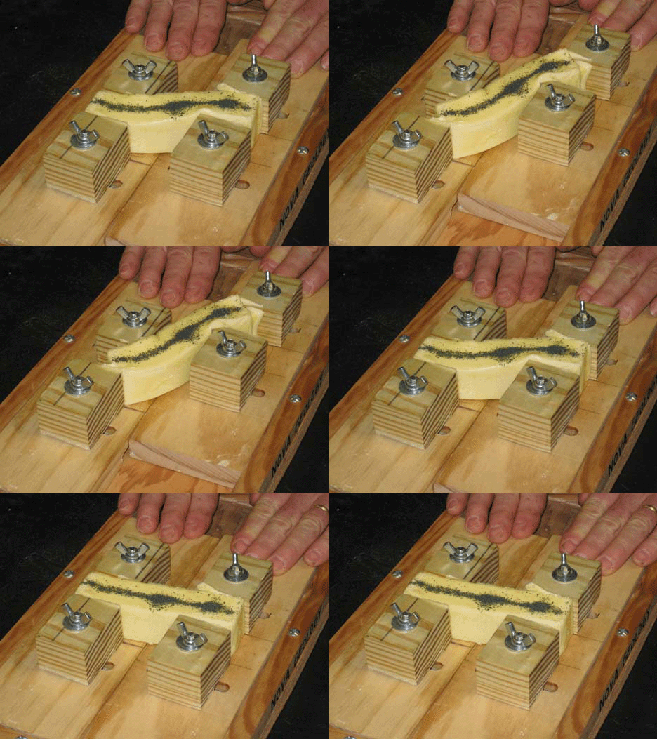
A million years ago, I posted about my inaugural attempt to use the Butter Buster to illustrate shear zone deformation to my structural geology students.

Today, using the UnFREEz program to make an animated GIF (Thanks, Lockwood!), I give you the Butter Buster animation:

“Geology of Skyline Drive” w/JMU

I mentioned going out in the field last Thursday with Liz Johnson‘s “Geology of Skyline Drive” lab course at James Madison University.

We started the trip south of Elkton, Virginia, at an exposure where Liz had the students collect hand samples and sketch their key features. Here’s one that I picked up:

skyline01

Regular readers will recognize those little circular thingies as Skolithos trace fossils, which are soda-straw-like in the third dimension. Rotate the sample by 90°, and you can see the tubes descending through the quartz sandstone:

skyline03

This is the Antietam Formation, a distinctive quartz sandstone / quartzite in the Blue Ridge geologic province. But at this location, on the floor of the Page Valley and butted up against the Blue Ridge itself, we see something else in the Antietam:

skyline02

Parts of this outcrop are pervasively shattered: a variety of sized clasts of Antietam quartzite are loosely held together in porcupine-like arrays of fault breccia. Turns out that this is the structural signature of a major discontinuity in the Earth’s crust: the Blue Ridge Thrust Fault. This is the fault that divides the Valley & Ridge province on the west from the Blue Ridge province on the east. And here, thanks to a roadcut on Route 340, we can put our hand on the trace of that major fault. Here’s another piece of the fault breccia:

skyline04

After grokking on the tectonic significance of this fault surface, we drove up into Shenandoah National Park, to check out some outcrops along Skyline Drive itself, but it was really foggy. Here’s a typical look at the team in the intra-cloud conditions atop the Blue Ridge:

skyline05

We checked out primary sedimentary structures in the Weverton Formation at Doyles River Overlook (milepost 81.9), like these graded beds (paleo-up towards the bottom of the photo)…

skyline07

…and these cross-beds. You can see that it was raining on us at this point: hence the partly-wet outcrop and glossy reflection at right:

skyline09

Cutting through this outcrop was a neat little shear zone where a muddy layer had been sheared out into a wavy/lenticular phyllonite, with a distinctive S-C fabric visible in three dimensions:

skyline06

Finally, we went to the Blackrock Trail, which leads up to a big boulder field of quartzite described as Hampton (Harpers) Formation. In some places, exquisite cross-bedding was visible, as here (pen for scale):

skyline10

Here’s a neat outcrop, where you can see the tangential cross beds’ relationship to the main bed boundary below them:

skyline11

…And then if you spin around to the right, you can see this bedform (with internal cross-bedding) in the third dimension. I’ve laid the pen down parallel to the advancing front of this big ripple:

skyline08

That last photo also shows the continuing influence of the fog.

Thanks much to Liz for letting me tag along on this outing! It was a great opportunity for me to observe another instructor leading a field trip, and also to discover some new outcrops in the southernmost third of the park.

Ball & pillow in cleaved Swift Run Formation?

On my structural geology field trip this past weekend, I made one major modification compared to last year’s iteration. I added a fifth detailed “field study area” at an outcrop of the Swift Run Formation, a Neoproterozoic sedimentary unit that is discontinuous in extent between the underlying Blue Ridge basement complex and overlying Catoctin Formation meta-basalts. A month ago, I didn’t know about this location, but I was introduced to it by Chuck Bailey on the Transect Trip last month. It’s a perfect complement to my structure students’ detailed examinations of the units above and below it, and the outcrop offers an embarrassment of rich structures to measure, both primary and secondary.

Here’s something I spent some time pondering: are there ball-&-pillow structures preserved in the Swift Run? We definitely see the ‘coarse-sand-dumped-on-mud’ set up that will lead to soft sediment deformation (sagging of heavy sand downward into squishy mud) under the right circumstances.

Okay, so with that in mind, take a look at this:

swifty_03

You’ll notice a clear contact here between dark, fine-grained mud (below) and lighter-colored arkose sand (above). The contact is irregular, so a sedimentologist unschooled in structure might start thinking about soft sediment deformation. But it’s not so simple as that: this rock is cleaved! The photo above is looking down parallel to the cleavage plane. Annotations:

swifty_03_anno

The boundary between the two strata tends to get a bit scrambled at this interface, with an increasingly zig-zaggy trace as deformation proceeds. Now, let’s rotate the same sample by 90°, and check out the trace of the bedding on the cleavage plane itself:

swifty_02

Pretty smooth line, eh? Not nearly so “EKG-ish” as what we observed in the first photo. This suggests that the wigglyness we saw in the first photo is a structural overprint, and not a primary sedimentary feature. We can then breath a sigh of relief, and just use this cleavage plane outcrop to point out what a nice graded bedding contact looks like:

swifty_02_anno

Here’s a second sample, as viewed on the edge where cleavage and bedding intersect. The little white dot is some kind of arthropod egg case; ignore it.

swifty_01

Whoa! significantly more up and down wiggles here to the contact between the two beds. Again, this could be a primary feature (soft sediment deformation), or it could be a structural overprint caused by the development of crenulation cleavage. I note how the bottom of the tan bed shows the large-amplitude wiggles, but the top does not. Now let’s turn this one 90° so we’re facing the cleavage face, and see what we see there:

paleo_pillows

Some annotations:

paleo_pillows_anno

I would not expect a structural re-organization of the bedding trace as viewed on the plane of foliation, only 90° to it. So the fact that the second sample shows the wiggles continuing around all exposed faces suggests to me that it is indeed a primary feature, but the alignment of the most-vertical parts of the sags was accentuated by the development of cleavage, as seen on the first face. This interpretation is backed up by the observation that the basal part of the sandy unit (the coarsest part) varies not only in position, but also in thickness as you trace it out around all sides of the sample.

I’m not entirely satisfied with this interpretation though, because of the asymmetry and small-scale “parasitic” wiggles on each of the potential sand “pillows.” Furthermore, when I’ve seen true ball-&-pillow soft-sediment deformation structures in the field, the mud that squishes up is typically in a cuspate form, in stark contrast to the lobate blobs of sand that sink down. Here in this Swift Run sample’s foliation plane, the shape character of the ups appears to match the shape character of the downs. On the first view (looking parallel to the bedding/cleavage intersection), however, I suppose one could argue that the mud approximates a flame structure (cuspate) while the sand pillows look more lobate… but with the cleavage overprint, it sure isn’t super obvious.

Anyone else want to chime in on these two samples? Observations? Interpretations?

The working life

It’s a rough life, working in the places I have to work… here are a few photos from yesterday’s field trip on the Billy Goat Trail with my NOVA Physical Geology students. Photos are courtesy Dr. Meg Coleman, who joined us for the hike.

A post-lunch lecture on river incision (note the two prominent bedrock terraces, a.k.a. “straths” in the background):
strath

The crew climbing the dreaded “Traverse” section of the trail:traverse

We had a nice hot day yesterday: almost 90° F! Tragically, the snack bar was closed when we got back to the visitor’s center, so we were denied our salutatory Italian ices. Back to the trail tomorrow, for the 4th of 5 trips this week…

Here, ptyggie ptyggie ptyggie!

Yesterday, I took my GMU structural geology class to the Billy Goat Trail, my favorite local spot for intriguing geology. Unlike last year, we managed our time well enough that we got to clamber around on the rocks downstream of the amphibolite contact. Here’s Sarah, Lara, Kristen, and Alan, negotiating a steep section:

IMG_2700

Justin, Joe, Nik, Aaron, Jeremy, and Danny find a chunky amphibolite boudin in metagraywacke. Notice how Jeremy is gesturing about the orientation of the metagraywacke foliation wrapping around the boudin.

IMG_2702

The thing that we found that really made me happy were these ptygmatic folds. Most of my readers will doubtless already be familiar with ptygmatic folding, but in case you’re new to this, check out this photo (ballpoint pen for scale):

IMG_2703

Ptygmatic folding is “intestine-like” in appearance. It results where there is a particularly high viscosity contrast (viscosity is resistance to flow) between the folded layer and the surrounding matrix. The higher viscosity material makes broad lobes, while the lower viscosity material may be found in the pointy cusps between those lobes. If ptygmatic folding is well developed, the limbs become parallel to one another (isoclinal), and the visual similarity to guts is disconcerting. Here’s a smaller version, a few feet away from the first one:

IMG_2706

I’m headed back to the Billy Goat Trail today to discuss the trail’s geology with a crew from Sigma Xi‘s D.C. chapter. I wonder what we will discover today?