Transect debrief 8: late brittle deformation

The final chapter in our Transect saga is now here. In some ways, it’s the least thrilling of the bunch. On the other hand, when I see a nice example of this structure, it makes me squeal like a little girl.

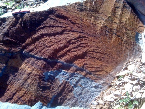
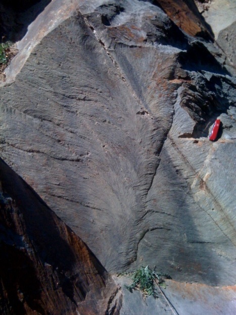
I refer, of course, to plumose structure, the small-scale architecture of a joint surface. We saw multiple great examples on the trip, but my favorites came with the first post-lunch stop on Transect Trip day #1, at an outcrop of the Weverton Formation showing a fine-grained deposit of siltstone.

I posted versions of both these photos previously via iPhone, but here I’ll give you the crisper Canon Elph version coupled with reposting of the iPhone shots for comparison purposes.

tt_11

tt_10

Plumose structure branches out in the joint propagation direction, the curvilinear “plumes” are thought to be perpendicular to the leading edge of the joint as it cracks through the rock. These late-stage brittle features may be related to the very latest part of Alleghanian deformation, or they may be related to recent uplift of these rocks.

All righty, then. I think that brings us up to the present day. Those of you who requested more details about the live-geoblogged photos, has this series answered your questions? If not, what do you need more details on?

Transect debrief 7: Brittle-ductile deformation

On the transect trip, I also saw some nice meso-scale “minor” structures that probably formed during Alleghanian deformation. Prominent among the ones that really impressed me were these en echelon tension gash arrays, deforming the Antietam Formation quartz sandstone and well exposed in blocks used to construct the wall along Skyline Drive and the Sandy Bottom Overlook in Shenandoah National Park:

tt_5

Good Lord! Ain’t those things beautiful? They also give us a lovely sense of the kinematics (relative motions) of the blocks of Antietam sandstone on either side of this sheared zone. In the case of the image above, the left side of the photo has moved “down” relative to the right side. The rock in between has torn and stretched, with the gashes opening up at right angles to the maximum stretching direction. As deformation proceeds, of course, the gashes rotate and deform, folding into “S” shapes.

Here’s one that’s more subtle:

tt_7

What you’re looking at in the image immediately above is a tension gash array that was a zone of weakness, exploited by later brittle deformation. The fracture which defines the edge of this block cracked through those old brittle-ductile tension gashes and split them clean in half.

Neat, eh? …Now check this out:

tt_9

Remember the Skolithos trace fossils? Here, you’re looking at a sideways cross section through some cylindrical Skolithos as they are disrupted by this zone of shearing. Note that the burrows tend to be highlighted by rust (hematite) staining: the brown lines that run roughly from the top left of the photo towards the bottom right. But look what happens to the orientation of those tubes where they are cut by the tension gash arrays: they are deflected into a new orientation, rotated from their original orientation!

If that’s a bunch of gobbledygook to you, consider this annotation:

tt_9_anno

I’ve drawn white lines to show the orientation of the Skolithos tubes in their undeformed and deformed states, colored the tension gashes yellow, and drawn on a set of blue arrows to show my kinematic interpretation (top to the left).

Here’s another block, showing the same phenomenon:

tt_8_anno2

Go ahead. Tell me you’re not impressed with that. I dare you. That is frakking AWESOME.

You are now dismissed.

Transect debrief 6: folding and faulting

Okay; we are nearing the end of our Transect saga. During the late Paleozoic, mountain building began anew, and deformed all the rocks we’ve mentioned so far. This final phase of Appalachian mountain-building is the Alleghanian Orogeny. It was caused by the collision of ancestral North America with the leading edge of Gondwana. At the latitude of Virginia, that means northwestern Africa (Morocco and/or Mauritania).

Whereas the first two pulses of Appalachian mountain building were relatively provincial affairs, this Alleghanian phase was a full-on continent-on-continent smackdown. The Himalaya (India colliding with Eurasia) would be a good modern analogue for the Pennsylvanian and Mississippian Appalachians.

When I was live-blogging the trip, I posted this photo of Judy Gap:

It was a bit hard to get it all into one measly iPhone frame (hence the tilted angle: those trees are in fact vertical!), but what you’re looking at here is the erosion-resistant Tuscarora Sandstone (Silurian in age; quartz-rich beach deposits) that outcrop as a ridge. However, here at Judy Gap, there are two ridges. What gives? This is where I was introduced to a new term that is apparently becoming a common phrase in the structural geology literature: contraction fault.

The story most Physical Geology students get about fault types is that tectonic extension causes normal faults, while tectonic compression causes reverse faults. Contraction faults are faults that display an apparent “normal” sense of motion, but were caused by a compressional tectonic regime. How the heck does that work, you may ask? Consider the following diagram:

So the deal with contraction folds is that they might start out “reverse” but are then rotated and tipped over as deformation proceeds. The former footwall becomes the new “hanging wall,” and the sense of motion is obscured by this new orientation. This means that they do represent contractional strain, but a freshman geology student is unlikely to spot it at first glance.

The Germany Valley to the east of Judy Gap is a big breached plunging anticline, as I attempted to show with this iPhone photo from the Germany Valley Overlook along Route 33:

It’s a bit easier to see if you jump up in the air 10 kilometers or so. Fortunately, that’s precisely why God created Google Earth:

The valley is hemmed in by a big V-shaped fence of mountains, all held up by the Tuscarora. It’s tough stuff. During Alleghanian folding, the crest of the anticline was breached, and water was able to get inside and gut the weaker rocks. The quarry annotated in the photo is mining the same Cambrian and Ordovician carbonates seen in the Shenandoah Valley back in Virginia (Lincolnshire and Edinburg Formation equivalents). A pattern geologists have noted with eroded anticlines is that older rocks are exposed in the middle of the structure, with younger rocks flanking them along the sides.

So that’s a glimpse of the big picture of deformation in the Valley & Ridge, but we can also see cool deformation at smaller scales… Stay tuned…

Transect debrief 5: sedimentation continues

We just looked at the Chilhowee Group, a package of sediments that records the transition for the North American mid-Atlantic from Iapetan rifting through to passive margin sedimentation associated with the Sauk Sea transgression. Well, if we journey a bit further west, we see the sedimentary stack isn’t done telling its story. The saga continues through another two pulses of mountain building. Consider this “unfolded, unfaulted” east-west cross-section cartoon:

vr_stack

Part A of the image above shows the overall stratigraphic sequence for the Blue Ridge and the Valley & Ridge provinces in Virginia and West Virginia. You’ll notice that the small, detailed stratigraphic column I used to start the last two posts covers just the bottom 6 layers in this stack. Zoomed out to the bigger picture, we see ~40 layers overall. Lynn Fichter of James Madison University, one of the leaders of the Transect Trip, has published an excellent information-dense guide to the mid-Atlantic column. It’s a terrific reference for anyone looking to learn more about these rocks and the story they tell.

Part B of the image above shows the tectonic interpretation of these different packages of rock — some represent rifting, some represent passive margin sedimentation, some represent clastic influence from various orogenies occurring to the east (Taconian and Acadian).

The cartoon cross-section below, modified from an original by Steve Marshak in his excellent introductory textbook Earth: Portrait of a Planet, shows the tectonic evolution of the east coast over the past ~1 billion years of geologic time. It is reprinted here with Steve’s permission.

full_eastUS

The story begins with the Grenville Orogeny, an episode of mountain building that completes the assembly of the Rodinian supercontinent. This is followed by Iapetan rifting, followed by three pulses of Appalachian mountain-building: the Taconian (“Taconic“) Orogeny, the Acadian Orogeny, and the culminating event of Pangean supercontinental assembly, the Alleghanian (“Alleghenian”) Orogeny. Finally, Pangea breaks up in the Mesozoic, an event also known as Atlantic rifting. Two complete Wilson Cycles are preserved by the Appalachian mountain belt!

The Valley & Ridge province received sediment courtesy of the Taconian and Acadian Orogenies, but wasn’t directly involved with the tectonic collision in any deformational way. Notice how west of both those orogenies in the Marshak diagram you see a fresh layer of sediment being deposited atop the North American craton.

During the field trip, I posted some iPhone photos of the sedimentary strata that accumulated in the Valley & Ridge during the mid-Paleozoic, shed off from the orogenic activity to the east. For example, the Brallier Formation’s turbidites record a time when sea was west and mountains were east. Or the Juniata Formation’s red beds speak of a time in the late Ordovician when an advancing clastic wedge had piled sediment up above sea level. This shot of some of those red beds preserves some beautiful depositional relationships from ~440 million year old river systems.

Let’s annotate that, shall we?

juniata_anno

Even in the Ordovician, rivers did what they do today, spilling over their bansk and building up natural levees. Same as it ever was, people.

That “sediment only; no deformation” regime for the Valley & Ridge changed with the Alleghanian Orogeny. That’s when deformation propagated to the west, encompassing the flat-lying Valley & Ridge strata into a proper fold-&-thrust belt. Later, differential erosion of these folded and faulted layers would etch the landscape into a series of valleys and ridges… hence the province name. More on that deformation in the next post.

Transect debrief 4: transgression, passive margin

…So where were we? Ahh, yes: an orogeny, and then some rifting. What happened next to Virginia and West Virginia? Let’s consult the column…

shenandoah_column

After the rifting event opened up the Iapetus Ocean, seafloor spreading took place and tacked fresh oceanic crust onto the margin of the ancestral North American continent. As North America (“Laurentia”) moved away from other continental fragments (Congo craton, Amazonia craton), it got a little bit calmer ’round these parts. From the continent’s perspective, the spreading center moving further and further offshore.

This shift of the tectonic locus out to the middle of an ocean basin means that the edge of the ancestral North American continent could finally relax a bit. The magmatic intrusions became a distant memory, and the crust cooled, contracted a bit, and sank. This subsidence allowed seawater to lap up onto the edge of the continent, and with the seawater came sediments. Rivers draining the exposed North American continent brought sediments to the sea, and dumped them. We geologists call this “passive margin sedimentation,” and it results in relatively “mature” sediments: those that have been well-worked over, typically rich in quartz and well sorted and with more rounded component grains.

As time went by, the edge of the continent subsided more and more, and any given spot in the modern-day Blue Ridge transitioned from streams to beach to continental shelf. The sedimentary stack reflects this increasing distance from the shoreline: a transgressive sequence.

It starts at the bottom with Weverton Formation: conglomerates and sandstones (and as I discovered on the Transect Trip, siltstones too). Here’s a piece of the Weverton from a GSW trip several springs ago:

The Weverton is overlain by muddy deposits of the Harpers Formation, which can also include coarse sandy units, as I learned on the Transect Trip. Here’s a shot of the Harpers Formation at Harpers Ferry, West Virginia, the type locality. This was taken five years ago, back when I had just gotten out of grad school, and spent a year teaching at George Mason University (pre-NOVA). [The student pictured is Steve Elmore, who just earned his master’s from GMU, working with Bob Hazen. Congratulations, Steve!]

steve_with_kink_bands_harpers_ferry

The Harpers is really important, because it contains some Olenellus trilobite fossils, which constrain its age to be Cambrian.

The Harpers is overlain by another sandstone: a clean, pure quartz package named the Antietam Formation. For me, the Antietam is a favorite local rock, because it is studded with Cambrian-aged Skolithos trace fossils. On the trip, I used the iPhone to upload a few photos of these, but here’s a higher-resolution image to savor:

You’re looking at the bedding plane of the Antietam in the above image, with your sight-line parallel to the paleo-vertical orientation of the tubes. Wow. Beyond all reason or deeper interest, I just love Skolithos tubes. I look at this outcrop, and I wonder: is this a palimpsest? or a small wormy Manhattan? In other words: was this multitude of burrows generated by a small population that dug in the same area over a long period of time, or by a huge population living cheek-to-jowl over a relatively brief moment?

Regardless, the sand-then-mud-then-sand-again picture painted by the succession of Weverton-Harpers-Antietam isn’t a “textbook” transgressive sequence, but it might make more sense if you consider the Antietam sands as barrier island deposits, with the Harpers being deposited in a Pamlico-Sound-type setting.

Finally, the transgression is complete when we get to the top of the Blue Ridge sequence and see the Tomstown Formation, a carbonate unit:

IMAGE CREDIT: USGS

The Tomstown tells of a time when sea level had gotten so high locally that the shoreline was way, way, way far away. There were no clastic sediments making it out to this location, and all that was available to precipitate were the ions dissolved in the seawater. No sand, no pebbles, no mud: only carbonate.

The sequence of sedimentary strata continues, but to follow its succession upwards, you’ll have to travel across the Blue Ridge Thrust Fault to the west, into the Valley & Ridge province. More on that in the next post. For the moment, let me share a cartoon sequence of images by Tom Gathright (1976), showing the overall stratigraphic evolution of the Blue Ridge province*:

*Note that Gathright used the outmoded names “Hampton” instead of Harpers, and “Erwin” instead of Antietam. Please forgive him and move on.

That last panel, showing Alleghanian deformation, is something we will attack in a future post. For now, I’m satisfied to have finally climbed to the top of the Blue Ridge stratigraphic stack.

_________________________________________

Gathright, Thomas M., 1976. Geology of the Shenandoah National Park, Virginia. Virginia Division of Mineral Resources Bulletin 86, Charlottesville, VA. [buy it from SNPA Bookstore]

Transect debrief 3: Rodinian rifting

The Grenville Orogeny, responsible for Virginia’s basement complex, was one mountain-building event among many that helped put together a Mesoproterozoic supercontinent called Rodinia. But Rodinia didn’t last: it broke apart during the Neoproterozoic to form the Iapetus Ocean basin. This rifting event is recorded in Virginia’s Blue Ridge province in the Swift Run Formation and the Catoctin lava flows.

It’s probably about time to start putting some of these rock units in stratigraphic context. Here’s my redrawing (and updating) of a cartoon Shenandoah National Park stratigraphic column based on an original by Tom Gathright (1976):
shenandoah_column

You’ll notice here that the Swift Run Formation is interbedded with the Catoctin Formation, a Neoproterozoic series of lava flows fed by fissure eruptions (kind of like what’s happening this week in Iceland).

Trickling downhill away from these fissure eruptions would have been flows of basaltic lava (tholeitic, indicating a mantle source chemistry). If you want a warmer modern analogue than Iceland, look to the Afar Triangle region of Ethiopia:

As with Neoproterozoic Virginia, the continental crust of modern Ethiopia is stretching, opening up topographic grabens which are being filled with clastic influx from the surrounding highlands and mafic lava which is formed from decompression melting in the underlying mantle, and funneled to the surface via feeder dikes. In places you will see streambed conglomerates interlayered with the mafic lava flows, and in places there are tuffs and rhyolites that are a (volumetrically-small) part of the package. Elsewhere there are lake sediments. The two bear a common geologic signature, despite being separated by thousands of miles and half a billion years. There’s that refrain again: Same as it ever was, same as it ever was.

Once on the surface, the lava cooled, and in some places, columnar jointing formed:

The cooling age on some of the rhyolitic upper units in the Catoctin Formation is 570-565 Ma (Rb/Sr on pyroxene by Badger and Sinha, 1988). Some mafic and felsic dikes (could be feeders) associated with the unit yield the same age via U/Pb (Aleinikoff and others, 1995).

At some point, ancestral North America (“Laurentia”) drifted away from the spreading center, and volcanism ceased. The crust cooled, subsided, and then a sequence of sedimentary rocks began to accumulate atop the cooled lava flows. This transgressive sequence of sediments (the Chilhowee Group) is the next thing up in the stack. More on that later.

Transect debrief 2: weathering the Grenvillian landscape

From the basement complex, the next unit up in the Blue Ridge province’s stratigraphic sequence is the Swift Run Formation. It rests atop an erosional unconformity. After the Grenville Orogeny (~1.1 Ga) added a swath of new crust along the margin of the North American continent, the landscape began to weather and erode. Eventually, an episode of rifting broke open rift valleys and a new ocean basin, the Iapetus. The Neoproterozoic rift valleys filled with sloughed-off detritus from the exposed Grenvillian rocks (granitoids, mainly), resulting in arkosic sediment. This arkose is mixed in with muddy layers: it looks very much like the much-younger rift valley sediments in the Culpeper Basin (Triassic rifting for those, not Neoproterozoic). This is the principle of uniformity at work. The same tectonics yield the same signature, even though they happen at different times. Same as it ever was, same as it ever was.

Here’s a reposted iPhone photo of some of the Swift Run, showing rip-up clasts of mudstone in the arkose:

Some of it is conglomeratic, with rounded quartz pebbles surrounded by immature-composition sand (reposted iPhone photo):

Later, during Paleozoic mountain-building (Alleghanian Orogeny), the Swift Run developed a penetrative cleavage. Here’s a photo showing bedding and cleavage intersecting in the Swift Run:tt_3

Annotated:
tt_3_anno

This is a cool outcrop: In spite of being polka-dotted with lichens, it shows primary bedding truncations (a primary geopetal sedimentary structure that tells us that up is “up” in this photo) as well as a small S-fold (top to the left) that probably resulted from Paleozoic Alleghanian deformation:tt_4

Annotated:
tt_4_anno

In spite of small folds and well-developed cleavage, I was shocked when someone on the field trip noticed this:tt_2

That’s two recumbent isoclinal folds! Annotated:
tt_2_anno

These folds may be just a local phenomenon formed as one layer of the Swift Run slipped over its neighbor… but they also may hint that deformation is more pervasive in this unit than a cursory glance would indicate. Quite interesting, if you ask me.

Take home lessons: (1) The Swift Run Formation is a post-Grenville rift-related sedimentary deposit. It is compositionally and texturally immature. (2) The Swift Run, like everything else in the Blue Ridge province, got deformed millions of years later during the Alleghanian phase of Appalachian mountain-building.

Transect debrief 1: starting in the basement

It is time to debrief the post-NE/SE-GSA field trip that I went on, affectionately dubbed the “Transect Trip” for the past 27 iPhone-uploaded “live”-geoblogged posts.

First off, I’d have to say that I enjoyed the live-field-blogging experiment overall, though I’ve got some critiques of the process and products. I think it’s amazing that I can upload photos and short blog posts from my iPhone to this site with a minimum of hassle. However, I can’t do much more than that. It’s not as easy to tag the posts or geotag the photos. I can’t compose annotations. In fact, I can’t even be sure the photos will be in focus, since the iPhone camera is a static lens. And there’s no macro feature on the iPhone camera, a source of some frustration for a guy like me that likes to photograph small things. Further, typing with my thumbs is laborious, keeping the live-geoblogged posts on the terse side.

So, when I asked what readers thought of the whole enterprise, I wasn’t surprised to get feedback that it would be nice to put things in a bit more context. I aim to start that process today, with the first rock we encountered, a charnockite (orthopyroxene-bearing granitoid). The rock type is named for Job Charnock, founder of Calcutta, India, whose tombstone is made of charnockite:

Charnockites are common rocks in the core of Virginia’s Blue Ridge “anticlinorium.” Here’s a nice photo of a fresh sample, showing the rusty/clayey weathering “rind” on the sample:

tt_1

Compare that image with this version, the original that I uploaded from the field trip via my iPhone:

Pretty profound difference in quality, eh?

So, here’s the deal with these charnockites. Volumetrically, they are a big part of the “basement complex” that cores the Blue Ridge. There are also a bunch of other flavors of granitoid down there; about fifteen discernible rock units in all. Our understanding of the basement complex has gotten a thorough re-working in recent years thanks to the coordinated efforts of many geologists who have focused on reexamining the Blue Ridge. Chief among these scientists in Scott Southworth of the USGS in Reston, who led an effort to remap the area in and around Shenandoah National Park. Dick Tollo (GWU), Bill Burton (USGS), Joe Smoot (USGS), Chuck Bailey (W&M), and John Aleinikoff (USGS) were part of the effort, too. The rocks were found to be more diverse than previously thought, and thus “complex.” Aleinikoff was responsible for a suite of new dates on the granitoids and their metamorphic successors in the basement complex. They have crystallization ages ranging from 1,183 Ma (±11 Ma) to 1,028 Ma (± 9 Ma): all Mesoproterozoic in age, and thought to be related to the Grenville Orogeny.

Some of these granitoids were deformed during Grenvillian mountain-building and attained a foliation which strikes northwest, in contrast to the later (Paleozoic) Appalachian foliation, which strikes northeast.

The plutonic rocks of the Blue Ridge province’s basement complex are the oldest rocks in Virginia, and they were the first ones we encountered on this field trip. All through that first day, we climbed upward through the stratigraphic column, meeting younger and younger rocks.