

Seeing my cat in this posture:

…made me think of this:

Where did those hind legs go?
Filed under: fossils, lola, mollusks | 2 Comments »


Seeing my cat in this posture:
…made me think of this:
Where did those hind legs go?
Filed under: fossils, lola, mollusks | 2 Comments »
Earlier in the month, during the big snowstorms, my window got plastered with snow. This snow formed a vertical layer which then deformed under the influence of gravity. Looking at it through the glass, I was struck by how it could serve as a miniature analogue for the deformation typical of a mountain belt.
Let’s start our discussion by taking a look at an iPhone photograph of the snow:

So here’s what I notice about this (vertically-oriented) photo:

The big sheet of snow is sliding downward over the face of the glass. This surface of slip is thus analogous to a low-angle thrust fault. Here, the maximum principal stress (known as σ1 to structural geologists) is gravity. The minimum principal stress (σ3) is perpendicular to the window, and the intermediate principal stress (σ2) is horizontal, parallel to the bottom edge of the window (i.e., left-to-right). As deformation proceeds, the snow slab folds up on itself and pooches outward in the area of least stress (σ3); away from the surface of the window.

As the snow layer moves downward, it creates a major fold which thickens the snow in a big line perpendicular to gravity, parallel to σ2. Along the vertical part of the window frame, the snow sheet has detached in a vertically-oriented fracture (i.e., parallel to σ1). Oblique to both σ1 and σ2 is a series of smaller folds with diagonal axes.
We can see a similar pattern in this map of the Himalayan mountain belt:

Note that the map* is oriented with north at the bottom, and south at the top, so as to be able to better compared it to my window. Note the broad arc of the Himalayan mountain front (~parallel to the Nepali border) which is perpendicular to the motion of India relative to Eurasia. The minimum principal stress direction (σ3) is vertical, which is why the mountains grow upwards (and the crust thickens downwards into the mantle, too, making the Himalayan mountain belt the site of the thickest crust on the planet). Along the edge of the impactor (analogous to our snow sheet), for instance in northern Burma, we see the same “splay” of folds with axes perpendicular to the the India-Eurasia convergence vector. The crust there is not as thickened.
Though a gooey slab of snow on my window isn’t a perfect analogue for Himalayan mountain-building, we can see some similarities in gross morphology — structural similarities that are fundamentally tied to the orientation of the principal stress directions.
_______________________________________
* Modified by me from a Google Maps “terrain” view.
Filed under: analogies, asia, faults, folds, himalayas, mountains, snow, structure | 5 Comments »
Last September, at the location of the faulted moraine (eastern Sierra Nevada, California), I took some photos of some of the sexier plutonic contacts exposed in big boulders (erratics) of the glacial till composing the moraine. Check them out. What do you see here?


Filed under: california, granite, igneous, mesozoic, sierras, structure | 9 Comments »
Today, some photographs from Guatemala. I know one of my geoblogopeers is down in Guatemala doing research, so I’ll be interested to hear her take on these photos. These photos all come to us courtesy of my friend Courtney, who is a librarian at M.I.T., and a fellow M.S.-graduate of the University of Maryland geology department. She shared these images with me about a year ago, and I intended to post them on NOVA Geoblog, but never got around to it. Well, the wait is over… it is time to feast your eyes on some lava! The full set of images is here.
Pacaya Volcano is about 50 miles south of Antigua. It is one of about 35 volcanoes in the country — and one of four active volcanoes. Courtney and her friends four-wheeled it part way up to save a couple hours of hiking time. The trip door to door from Antigua was seven hours or so. They drove to about 1850′ elevation (564 m) and hiked the rest. Pacaya is 2,552′ high (778 m), but they didn’t go all the way to the top, just high enough to get up close and personal with some lava.
Here they are hiking up across relatively fresh lava flows:
“Lava stairs” that the group used to hike up. Courtney says, “This was live lava about two weeks prior to this picture. When the guide told me how recent it was, I started to get a little panicked. I put my hand down on the ‘stairs’ and it was very warm to the touch. Yikes.”

The group approaches the incandescent lava river (seen here as a faintly orange band running from upper left to lower right):
Approaching the lava river itself:
Wow. I’m struck by the ‘natural levees’ that form on either side of the liquid flow. The overall morphology calls to mind the neural tube of an embryo…

Here’s an unsettling sight to see on the “trail.” Courtney reports very hot feet on this hike, so I’m really not sure whether this is safe or foolhardy.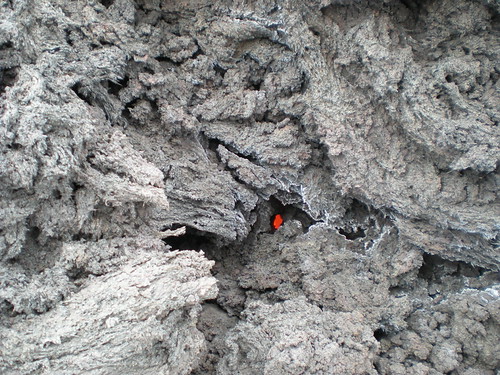
In these next two images, watch a big chunk of solidified basalt (shaped like an anvil, dark in the first picture, rolled over to appear orange in the second picture) ride the current downstream, like a log floating down a river:
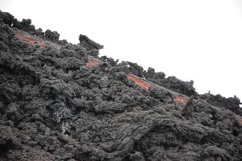

The hikers, evidently happy with their experience. You can see the lava river in the distance as an orange stripe on the side of the volcano:
I’d like to thank Courtney for sharing these photos with us. What do you think? Was this safe? Was it awesome regardless?
Filed under: basalt, central america, guatemala, travel, volcano | 5 Comments »
On last May’s GSW spring field trip to Chain Bridge Flats, I saw a quartz vein:

Surely, upon looking at this photograph, you will be struck by the way the vein is not the same thickness along its length, and parts of it appear to be a white line transitioning into a parallelogram, and back into a white line again. What, you make ask, gives?
I think what you’re looking at here is a transtensional quartz vein. Like all veins, this one formed when the host rock (in this case, metagraywacke of the “Sykesville Formation”) cracked open and hot fluids squirted into that fracture. Elements dissolved in the fluid organized themselves into mineral crystals, and precipitated in the void space of the crack, sealing it shut with quartz “glue.”

“Transtension” is the word used to describe a kinematic regime which contains elements of transform “shear” (in this case, right-lateral) and tensional stress. Because of the jagged shape of the fracture here, some parts of the fracture are grinding past their neighbors, while other parts are dilating. The dilating parts are only dilating because of the shape of the fracture. The actual motion of the blocks of rock is uniform and non-rotational. We call these little pulling-apart areas “releasing bends.”
On a much larger scale (lithosphere-scale), releasing bends near the surface create pull-apart basins like the Dead Sea. Deeper in the crust, pull-aparts may serve to accommodate pluton emplacement, as has been suggested by Tikoff & Teyssier (1992) for the Tuolumne Intrusive Suite of the high Sierra in California.
This “part-sliding, part-extension” pattern is actually quite common. Here’s another example, this one in a brick sidewalk on Capitol Hill:

The same pattern also shows up at the Mid-Atlantic Ridge, where the extensional segments (north-south-oriented) are sites of new oceanic crust being formed, and the fracture networks (east-west-oriented) are sides of transform faults, where the South American Plate slides laterally past the African Plate:

Where else have you seen this pattern? Use the comments section to share an example or two.
Filed under: california, dc, piedmont, quartz, structure | Comments Off on Transtensional quartz vein
A few photos from last May’s spring field trip with the Geological Society of Washington… Here’s the group at Chain Bridge Flats (far westernmost-Washington, D.C.), looked at the metamorphic rocks there — a metagraywacke melange known as the Sykesville Formation.

Another group shot, with field trip leaders Tony (khaki shirt) and Gary (red jacket) Fleming in the foreground:

Euhedral metamorphic pyrite crystals (porphyroblasts):

An elusive bedding plane in the Sykesville Formation (a rare thing to see, as the rock has been pervasively metamorphosed and deformed):
Annotated version of the same, highlighting the grain size change that defines the bedding plane:
Boulder of Cambrian-aged Antietam Formation quartzite, washed ~25 miles downstream by the Potomac River, bearing characteristic Skolithos trace fossils.

A close-up of the side of this boulder, showing another trace fossil, Diplocraterion, as well as one of the Skolithos tubes.

Annotated version of the same photograph:
Finally, another piece of the Antietam Formation, this one only cobble-sized, showing another example of Diplocraterion:
GSW field trips are free and open to the general public. If you’re in the D.C. area, watch the D.C. Geology Events website for opportunities like this, and then come on along and join the fun!
Filed under: cambrian, dc, gsw, metamorphism, minerals, paleozoic, piedmont, primary structures, sediment, trace fossils | Comments Off on GSW spring field trip
Guess which day I launched the blog?

Thanks to everyone who has stopped by so far.
I’ve gotten the same question several times from several readers, so let me address it here for everyone’s edification: Yes, NOVA Geoblog will be left “as is,” where it is. You can link to it, or bookmark it, or rely on its presence as you see fit. It’s “fossilized!” The comments are now closed, so what you see now is what it will remain into the future.
Today, you get a photo of a fossilized crinoid stem, from the Mississippian-aged Lodgepole Limestone of the Bridger Range, north of Bozeman, Montana. A pencil is provided for scale:

Zoomed-in a bit, and cropped. The segments (“columnals”) show up nicely:

Crinoids are echinoderms, the invertebrate phylum which includes sea urchins and sea stars. However, at first glance you might think they were plants, as they are sessile (mainly sessile, anyhow) and have an overall form much like a kindergartner’s sketch of a flower. This morphology is where their common name, sea lilies, comes from.
Filed under: echinoderms, fossils, mississippian (carboniferous), montana, rockies | Comments Off on Fossil crinoid stem
A friend forwarded this via e-mail to me today… U.K. readers may be interested in participating.
Millstone Grit? Kimmeridge Clay? Old Red Sandstone? Durness Limestone?
Yorkshire Lias? ………. What are YOUR top three British sediments?
BSRG (British Sedimentological Research Group) are conducting a small survey to find out what formations geologists consider the “best” sedimentary deposits across the United Kingdom.
This sounds like a loony piece of work (and it is) but the results
have been quite surprising so far (millstone grit? the best? really?!).
BSRG are trying to get more people involved in this survey (approx 150
so far). To join in, email your top three favourite formations, in
order (+ your name and your profession) to: top3formations@hotmail.com
Filed under: sediment, surveys, united kingdom | Comments Off on U.K. sediment survey
Mark your calendars! Prehistoric: D.C. will profile (part of) the ancient past of Washington, D.C., in an episode to air February 28, 9pm, on the Discovery Channel.
Filed under: dc, mesozoic, television | 1 Comment »
Callan Bentley
